Futako-Tamagawa about 60 years ago and today
Then and now


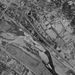


Nearby single photograph taken: June 26, 1963 (0.2 km from this spot)
What to compare in this era:
Controls: drag to move / right-drag to rotate and tilt / scroll while holding ⌘ or Ctrl to zoomControls: slide with two fingers to move / pinch to zoom / drag two fingers up or down to tilt
Note: the 3D elevation data is based on current surveys, not on the terrain at the time of the photograph. Elevation tiles: processed from GSI Tiles
The 3D view could not be loaded. Check your connection and try again.
Note: the terrain shading is based on current surveys, not on the terrain at the time of the photograph. Hillshade map: processed from GSI Tiles
Note: the map is today's, not a map from the time of the photograph. Map: © OpenStreetMap contributors
Source: processed from GSI Tiles (aerial photographs by era / latest nationwide photographs / single photographs)
Explore this area on the mapMove the map to compare the surroundings then and now as well.
Overlay and compare the 1961-1969 aerial photograph and today's photograph of the Futako-Tamagawa area, Tokyo. All photographs are published by the Geospatial Information Authority of Japan (GSI).
Eras of photographs for this location
For the Futako-Tamagawa area, aerial photographs from the following eras can be compared.
The old photographs of this location cover 7 eras from c. 1936-1942 to 1987-1990; as of 2026, the newest photograph, 1987-1990, is 37 years ago.There are no photographs of this location from after that until today. The differences between eras are summarized in the guide to aerial photograph eras.
Coverage for each era differs by region. Only the eras that actually have photographs of this location are listed here.
Elevation of this location
The elevation (above sea level) near Futako-tamagawa Station is 12.9 m (source: GSI elevation API). Elevation profiles running east-west and north-south through this location are also shown.
Profile positions (vertical green line = north-south / horizontal blue line = east-west)
Elevation is the value at the ground surface (even where a station is underground or elevated, the value is for the ground surface). Elevation is only one factor in disaster preparedness. Check actual risks such as flooding on the Hazard Map Portal Site and the hazard maps published by local governments.
Elevation tiles for the profiles: processed from GSI Tiles
Access by rail
Futako-tamagawa Station is served by the following lines.
- Tokyu Oimachi Line
- Tokyu Den-en-toshi Line
Source of line information: processed from National Land Numerical Information (Railway Data / Ministry of Land, Infrastructure, Transport and Tourism).
Change seen in the share of built-up area
This compares land use in 1976 and 2021. The share of built-up area within 500 m changed from 40% to 58%. Among the locations on this site, the spread of built-up area here is in the middle. The bar below shows where this location falls in the distribution across the locations on this site.
Source: processed from National Land Numerical Information (Land Use Subdivision Mesh / 1976 and 2021 / Ministry of Land, Infrastructure, Transport and Tourism). The texture value (amount of fine detail) of the photographs changed from 17.3 to 34.5. This is a mechanical comparison between photographs and includes differences from the shooting season and from black and white versus color, so treat it only as a rough guide.
Official land prices over time
The official land price (Chika Koji) standard site nearest to this location is "1-949-3 Seta, Setagaya Ward, Tokyo" (about 562 m in a straight line; use: Residential). The official prices per square meter at this standard site from 2016 to 2026 are shown below. The 2026 official price is 871,000 yen.
View as a table
| Year | Official price |
|---|---|
| 2016 | 615,000 yen |
| 2017 | 645,000 yen |
| 2018 | 696,000 yen |
| 2019 | 719,000 yen |
| 2020 | 731,000 yen |
| 2021 | 731,000 yen |
| 2022 | 734,000 yen |
| 2023 | 749,000 yen |
| 2024 | 777,000 yen |
| 2025 | 820,000 yen |
| 2026 | 871,000 yen |
Source: processed from National Land Numerical Information (Land Price Publication Data / Ministry of Land, Infrastructure, Transport and Tourism). Official land prices are values published for standard sites as of January 1 each year and do not show the transaction price of any particular piece of land. The selection and location of standard sites may be reviewed from year to year.
Nearby locations
Sorted by distance from Futako-Tamagawa. Comparing them together shows how the same area has changed over time.
Select a marker on the map to see the location name and a link to it.
Locations with the same origins
Towns in the same category as Futako-Tamagawa (Redevelopment), chosen from other regions. You can compare what they share in land use and town layout.
Select a marker on the map to see the location name and a link to it.
Articles that feature this location
Old photographs of four stations on the Den-en-toshi Line: from Futako-Tamagawa to Minami-Machida
Tokyo and Osaka in prewar aerial photographs from around 1936-42
Read the elevation along the Tama River: Tonomachi, Kawasaki, Musashi-Kosugi, and Futako-Tamagawa
Old photographs of tower apartment towns: Musashi-Kosugi, Ebina, and Musashi-Urawa
Recently viewed towns
This history is saved only on your device and is not sent to any server. Depending on your browser settings, it may be deleted automatically if you do not visit for a while (it is less likely to be deleted if you use the site as an app).
Why not look at how another town has changed?
History of Futako-Tamagawa
The Tama River flows while cutting the southern edge of Setagaya, leaving a wide lowland on its left bank. Futako-Tamagawa Station stands on that lowland, in the part closest to the river. The heights around the station divide into two steps. The north at 13.6 m, the station position at 12.9 m and the east at 12.7 m line up at around 13 m, and from there drop one step to 9 m in the south and 7.6 m in the west. The two low ones are both on the side facing the riverbed of the Tama River, and the step of more than 5 m is itself the mark of the river's cutting. The place name combines the names of two pieces of land across the river, with Futako on the opposite bank and Tamagawa on this bank side by side. Before a bridge was built it was a place connected by ferry, land where people crossing the river and people carrying gravel out of the riverbed came and went. The core of the town moved to the station area much later.
A white riverbed and a single bridge
In the c. 1936-42 aerial photograph, the Tama River cuts the frame diagonally from the upper left to the lower right. Its water channels are thin, and on both sides the riverbed of shining white gravel is surprisingly wide. The flow does not gather into one, splitting within the riverbed, going around sandbanks and rejoining. Only one bridge crosses the river in the frame, a road extends northeast from its foot, and rows of houses are dense only on both sides of that road. Outside, it is mostly lots of fields and paddies. Toward the upper right, a band of dark woods continues diagonally, and the boundary between the lowland and the plateau can be read as a line. It is the figure of an era when the foot of the bridge was the core of the town.
The 1945-50 photograph is fine-grained, and the state of the riverbed can be seen even better. The white of the gravel spreads further, and inside the riverbed long, narrow sandbanks remain like islands. There is still only one bridge, rows of houses on its northeast side have gained thickness, and in the upper right of the frame lots finely divided by roads begin to line up. On the opposite bank in the lower left, paddies and fields are wide, and houses only line up thinly along the roads. Across the same river, the way the town advances is completely different between the right bank and the left bank.
Lines drawn on the riverbed
1961-69 is the era included from the start on the older side of the slider at this location. Both banks are already filled with houses, the field lots have been pushed to the corners of the frame, and buildings come close up to the inside of the embankment line along the river. The riverbed has also changed: on sand that had been only white, faint grid lots have been drawn. In the upper left of the frame a small stream joins the Tama River, and a gravel riverbed also opens around that confluence.
In 1974-78 color arrives, and you can see what the lots on the riverbed are. In the upper left of the frame, where the riverbed is wide, several round shapes line up, with the soil of the infields appearing as brown circles. It is a riverbed laid out as sports grounds. The water channels are greenish and thin, and the contrast with the brown riverbed is clear. In the lower right of the frame, a wide motorway crosses the river at a high level, running diagonally through the urban areas on both banks.
The 1979-83 photograph is another face of the same river. The water has turned muddy yellowish brown, covering the sandbars and spreading across the full width of the riverbed. Only the midstream sandbar remains above the water like an island, and the sports grounds on the riverbed meet the water's edge with their green turf. It is a photograph from a day of high water, and opened after seeing the usual thinness of the water, it shows how much width this river naturally uses. At the same time, you can read that the water has not reached the streets outside the embankment. However, a single photograph shows only the range the water reached that day, and the official hazard map of Setagaya Ward shows how far inside and outside the embankment falls within the assumed flooding area.
In 1984-86 the water has receded, and the sandbars and grassland return. The sports grounds on the riverbed appear divided into brown infields and grassy outfields, and in the middle of the left bank a row of white buildings and lots divided into squares line up. At the left edge of the frame, a single large building with a blue roof stands out. By 1987-90 the use of the riverbed advances further. Below the center, reddish-brown square lots also line the edge of the riverbed, and on the bank a little right of the center a blue water surface and green sports grounds appear. The east side of the station is still occupied by low buildings and lots blanked out in white that look like parking lots, and nothing tall stands.
From an amusement park to a mixed-use complex
The character of this town is made up of the overlap of river leisure, shopping and the railway. The riverbed of the Tama River has long been a place for outings, an amusement park was placed along the river, and its name was also included in the station name. The amusement park closed in 1985, and its site later moved to another use. Its face as a shopping town came much earlier: in 1969 a department store opened on the east side of the station, becoming a forerunner of the form of placing large sales floors in the suburbs. The station name was changed to Futako-Tamagawa in 2000. Then in 2011 the first phase of a mixed-use complex opened in the block on the east side of the station, and the second phase was added in 2015. In a form that stacks offices, commercial facilities and housing in one block, the flow of people gathered at the transfer station between the Oimachi Line and the Den-en-toshi Line.
Rooftop green and thin water channels
In today's photograph, only one block east of the station differs in color tone. Several long, narrow rectangular buildings line up facing the same way, their roof surfaces appearing dark gray and standing out from the low white roofs around them. The station itself can be read as a long, narrow white roof, a large flat-roofed building continues to its southeast, and a green plaza sits on its roof. From above, if anything, you can see more easily that round turf and groves of trees are on top of a building. To its southeast there is a corner where groves and grassland spread, with a small water surface shining inside. Going back and forth with the 1987-90 photograph, you notice that the same position was low buildings and white parking lots. On the other hand, the river side has hardly moved. The water channels are thin, the sandbars white, and the grassland on the riverbed wide. The sports ground lots in the upper left have also not changed place since 1974-78. To the extent that the town has grown vertically, the composition makes the flatness of the riverbed stand out. Toward the bottom of the frame a building with a large white roof has been built, and the urban area on the opposite bank has also been filled without gaps.
The record of values only exists from 2016 on. For a residential site in Seta 1-chome, about 560 m from the location, the value was 615,000 yen per square meter in 2016 and 871,000 yen in 2026, and in the record up to the 2026 publication the former is the lowest and the latter the highest. It is a form in which the high price came in the years after the mixed-use complex opened in two phases.