Tama New Town (Tama Center) about 60 years ago and today
Then and now


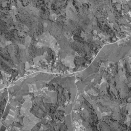


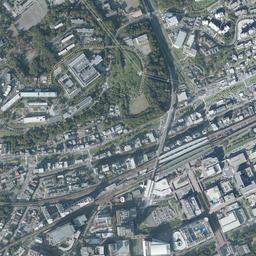


Center photograph taken: 1961-68
What to compare in this era: The hills of dark, dense mixed woods are replaced, frame and all, by pale pink bare ground. Only the green band remaining at the top edge does not change in either era, and it is the boundary of how far the cutting went
Controls: drag to move / right-drag to rotate and tilt / scroll while holding ⌘ or Ctrl to zoomControls: slide with two fingers to move / pinch to zoom / drag two fingers up or down to tilt
This 3D terrain is today's. The mismatch when you overlay an old photograph is the evidence of the land development that cut hills and filled valleys.
Note: the 3D elevation data is based on current surveys, not on the terrain at the time of the photograph. Elevation tiles: processed from GSI Tiles
The 3D view could not be loaded. Check your connection and try again.
Note: the terrain shading is based on current surveys, not on the terrain at the time of the photograph. Hillshade map: processed from GSI Tiles
Note: the map is today's, not a map from the time of the photograph. Map: © OpenStreetMap contributors
Source: processed from GSI Tiles (aerial photographs by era / latest nationwide photographs / single photographs)
Explore this area on the mapMove the map to compare the surroundings then and now as well.
Overlay and compare the 1961-1969 aerial photograph and today's photograph of the Tama New Town (Tama Center) area, Tokyo. All photographs are published by the Geospatial Information Authority of Japan (GSI).
Eras of photographs for this location
For the Tama New Town (Tama Center) area, aerial photographs from the following eras can be compared.
The old photographs of this location cover 5 eras from 1961-1969 to 1987-1990; as of 2026, the newest photograph, 1987-1990, is 37 years ago.There are no photographs of this location from after that until today. The differences between eras are summarized in the guide to aerial photograph eras.
Coverage for each era differs by region. Only the eras that actually have photographs of this location are listed here.
Elevation of this location
The elevation (above sea level) near Tama-Center Station is 88.6 m (source: GSI elevation API). Elevation profiles running east-west and north-south through this location are also shown.
Profile positions (vertical green line = north-south / horizontal blue line = east-west)
Elevation is the value at the ground surface (even where a station is underground or elevated, the value is for the ground surface). Elevation is only one factor in disaster preparedness. Check actual risks such as flooding on the Hazard Map Portal Site and the hazard maps published by local governments.
Elevation tiles for the profiles: processed from GSI Tiles
Access by rail
Tama-Center Station is served by the following lines.
- Tama Toshi Monorail Line
Source of line information: processed from National Land Numerical Information (Railway Data / Ministry of Land, Infrastructure, Transport and Tourism).
Change seen in the share of built-up area
This compares land use in 1976 and 2021. The share of built-up area within 500 m changed from 8% to 82%. Among the locations on this site, the spread of built-up area here is among the largest (top 20%). The bar below shows where this location falls in the distribution across the locations on this site.
Source: processed from National Land Numerical Information (Land Use Subdivision Mesh / 1976 and 2021 / Ministry of Land, Infrastructure, Transport and Tourism). The texture value (amount of fine detail) of the photographs changed from 12.5 to 39.4. This is a mechanical comparison between photographs and includes differences from the shooting season and from black and white versus color, so treat it only as a rough guide.
Official land prices over time
The official land price (Chika Koji) standard site nearest to this location is "1-22-7 Ochiai, Tama, Tokyo" (about 721 m in a straight line; use: Residential). The official prices per square meter at this standard site from 2002 to 2026 are shown below. The 2026 official price is 266,000 yen.
View as a table
| Year | Official price |
|---|---|
| 2002 | 251,000 yen |
| 2003 | 240,000 yen |
| 2004 | 224,000 yen |
| 2005 | 217,000 yen |
| 2006 | 217,000 yen |
| 2007 | 222,000 yen |
| 2008 | 233,000 yen |
| 2009 | 227,000 yen |
| 2010 | 215,000 yen |
| 2011 | 212,000 yen |
| 2012 | 210,000 yen |
| 2013 | 210,000 yen |
| 2014 | 213,000 yen |
| 2015 | 216,000 yen |
| 2016 | 218,000 yen |
| 2017 | 220,000 yen |
| 2018 | 222,000 yen |
| 2019 | 223,000 yen |
| 2020 | 224,000 yen |
| 2021 | 224,000 yen |
| 2022 | 225,000 yen |
| 2023 | 229,000 yen |
| 2024 | 240,000 yen |
| 2025 | 252,000 yen |
| 2026 | 266,000 yen |
Source: processed from National Land Numerical Information (Land Price Publication Data / Ministry of Land, Infrastructure, Transport and Tourism). Official land prices are values published for standard sites as of January 1 each year and do not show the transaction price of any particular piece of land. The selection and location of standard sites may be reviewed from year to year.
Nearby locations
Sorted by distance from Tama Center. Comparing them together shows how the same area has changed over time.
Select a marker on the map to see the location name and a link to it.
Locations with the same origins
Towns in the same category as Tama Center (New town), chosen from other regions. You can compare what they share in land use and town layout.
Select a marker on the map to see the location name and a link to it.
Articles that feature this location
An elevation comparison. Read low towns and high towns from the terrain
Towns born by cutting away mountains. Traces of new town grading
Places where a new station and a town were born at the same time, seen in aerial photographs
Compare aerial photographs by era: from 1928 to fiscal 2007
How to read old aerial photographs: how to use Kakomap
Sixty years of the three great new towns: Senri, Tama, and Senboku
Aerial photographs from 1974-78: what stage of grading is Tama Center at?
Recently viewed towns
This history is saved only on your device and is not sent to any server. Depending on your browser settings, it may be deleted automatically if you do not visit for a while (it is less likely to be deleted if you use the site as an app).
Why not look at how another town has changed?
History of Tama New Town (Tama Center)
If you open the 1974-78 photograph, most of the frame is tinted a pale pink. It is the color of prepared land with the soil laid bare. Green hills and old hamlets remain only in a thin band at the top edge, and below that, bare ground continues to the edges. The rise and fall of the hills can still be read, but the woods and paddies that must have sat on them are gone. The moment when the hills were once returned to cleared land to build a single town is captured in this photograph.
The hills of mixed woods before they were cut
You can confirm what lay beneath in the photograph of the era just before. The 1961-69 frame is hills of dark, dense mixed woods from corner to corner. Small bright fields and paddies line up only at the bottoms of the valleys, the roads only follow the valley lines thinly, and there is no straight, wide road anywhere. Clusters of roofs gather about ten houses at a time at the mouths of the valleys. The texture value, which turns the fineness of the structures in the photograph into a number, is low in this era at 12.5, and the thinness of human activity shows directly in the figure. Mixed woods, tended for generations to obtain firewood, charcoal, and fallen leaves to spread on paddies, overlapped layer upon layer at the western edge of Tokyo.
If you look at the elevation, it is 88.6 m around the station, 103.8 m if you swing south, and 98 m in the west, a chain of peaks around 100 m. It is in the very midst of the Tama Hills, and on the high side at that. Although it lies a little over 30 km from Shinjuku, this height and the fineness of the valleys held back the spread of farmland and the growth of towns. That is exactly why, when Tokyo, short of housing, sought land for several hundred thousand people, it was these hills that remained in one piece.
A method of buying up and building
In 1965 the city plan for Tama New Town was decided as a New Residential Town Development Project. It is a system in which the developer buys up the land in the area, prepares it, and supplies it as housing lots, and it proceeds differently from a method that builds up landowners' agreement one lot at a time. The area spanned four cities from the City of Inagi to the City of Machida, and it became one of the largest planned cities in Japan. The work of cutting the hilltops and dropping that soil into the valleys to make flat surfaces was repeated over the whole area, and in 1971 residents began moving in in the Suwa and Nagayama districts at the eastern end. Tama Center is the core district placed at the center of this town, and at the time the town opened it was still in the middle of construction.
When residents began moving in, no railway had reached these hills. For three years after the first residents moved in, the only way to central Tokyo was to rely on route buses. Houses rose on the hills, and the tracks that served them followed later. This way of proceeding, which looks like the reverse order, was also the other side of the method of buying up the area as a whole and then preparing it all at once.
The tracks that came before the town
In 1974, two private railways reached the top of these hills one after the other. The many tracks running side by side east-northeast through the middle of the bare ground draw the eye in the 1974-78 photograph. The order, in which the tracks were laid before the town and the surroundings remained bare soil, can be seen clearly. The stations of the two companies were placed side by side, and each is called by a name that carries its company's name. The overlap of station names remains as a sign that two companies came into one core district at the same time. The residential area on the hills was directly linked to central Tokyo from this year, but it took more time still for the station area to rise as a town.
If you look closely at the photograph of the same era, in the left half of the frame, white slopes cut out in steps and black woods left uncut alternate. This stripe-like pattern shows that the hills were not flattened all at once but cleared one pair of ridge and valley at a time. The places where the islands of woods were left lead directly to the positions of later parks and green spaces on the slopes.
In the 1979-83 photograph, several buildings begin to line up on the north side of the tracks, while the south side remains wide, flat vacant land. In 1984-86 the number of buildings increases and greenery begins to return to the cut slopes, but there is still an open surface at the center of the core district. In the 1987-90 photograph that blank is mostly filled, and a group of large buildings appears in the station area. It took over twenty years from the decision for the center of the plan to finally gain substance. In this district the idea of separating roads for cars and paths for pedestrians by height was carried through, and the wide pedestrian path and bridges running from the station area to the park were prepared first as the framework of the town.
The end of the age of construction
Roles were added to the town too. In 1990 Sanrio Puroland opened, adding to a town for living a place that draws people from outside. In 2000 the Tama Toshi Monorail Line opened along its whole length, linking an axis running north and south through Tama. The land preparation itself ended as a project in 2006, and the age of construction, more than 40 years long, has come to a close. As of 2026 the texture value has increased to 39.4, more than three times that of the era of the hills of mixed woods.
From there on, the theme shifts to how to renew a mature town. Rebuilding has begun for the residential buildings in the districts first moved into, and in residential areas clinging to the slopes of the hills, going up and down slopes and stairs has become an issue of daily life. Being one of the largest in Japan also means that aging comes on the same large scale. On the other hand, the legacy of the early plan, the wide pedestrian paths and the large parks, has remained as an asset that cannot be remade later.
The official land price (Chika Koji) of residential land in Ochiai 1-chome, about 720 m from the station, fell from 251,000 yen per square meter in 2002, with a phase of small recovery in 2007 and 2008 in between, hit the bottom of the record up to the 2026 publication at 210,000 yen in 2012 and 2013, and then recovered to 252,000 yen in 2025. It came back to almost the same value by 2025, and in the 2026 publication it was 266,000 yen, above the 2002 value.
The hills themselves remain in the places left uncut. In the photograph as of 2026, black clumps of woods are scattered here and there among the town, and most of them are mixed woods enclosed as parks and green spaces on the slopes. At the lower left of the frame, a corner where many long, narrow strips of lawn line up along the valley lines continues in almost the same shape from the 1961-69 photograph to the photograph as of 2026. The hand of cutting did not reach here. If you follow the pedestrian paths and climb the slopes, you can confirm with your feet that the rise and fall of the hills lives on beneath the town smoothed flat.