Otaru-Chikko (Wing Bay Otaru) about 60 years ago and today
Then and now
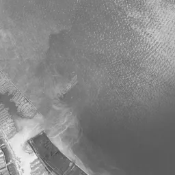
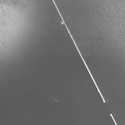


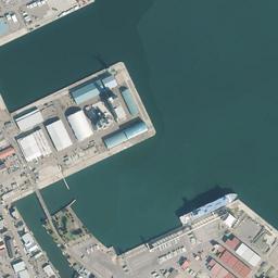
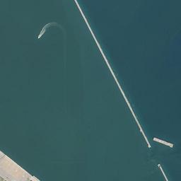






Center photograph taken: 1961-67
What to compare in this era: Count the thin lines lined up in parallel in the band along the shore and the short dotted rows between them. In the compartments offshore there are pale bundles lined up in arcs
Controls: drag to move / right-drag to rotate and tilt / scroll while holding ⌘ or Ctrl to zoomControls: slide with two fingers to move / pinch to zoom / drag two fingers up or down to tilt
Note: the 3D elevation data is based on current surveys, not on the terrain at the time of the photograph. Elevation tiles: processed from GSI Tiles
The 3D view could not be loaded. Check your connection and try again.
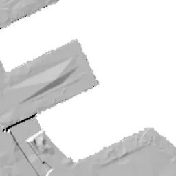
Note: the terrain shading is based on current surveys, not on the terrain at the time of the photograph. Hillshade map: processed from GSI Tiles
Note: the map is today's, not a map from the time of the photograph. Map: © OpenStreetMap contributors
Source: processed from GSI Tiles (aerial photographs by era / latest nationwide photographs / single photographs)
Explore this area on the mapMove the map to compare the surroundings then and now as well.
Overlay and compare the 1961-1969 aerial photograph and today's photograph of the Otaru-Chikko (Wing Bay Otaru) area, Hokkaido. All photographs are published by the Geospatial Information Authority of Japan (GSI).
Eras of photographs for this location
For the Otaru-Chikko (Wing Bay Otaru) area, aerial photographs from the following eras can be compared.
The old photographs of this location cover 2 eras from 1961-1969 to 1974-1978; as of 2026, the newest photograph, 1974-1978, is 50 years ago.There are no photographs of this location from after that until today. The differences between eras are summarized in the guide to aerial photograph eras.
Coverage for each era differs by region. Only the eras that actually have photographs of this location are listed here.
Elevation of this location
The elevation (above sea level) at the reference point of Otaru-Chikko (Wing Bay Otaru) is 3.2 m (source: GSI elevation API). Elevation profiles running east-west and north-south through this location are also shown.
Profile positions (vertical green line = north-south / horizontal blue line = east-west)
Where the line in a profile breaks off and leaves a gap, no elevation data is available (water surfaces such as the sea or rivers).
Elevation is the value at the ground surface (even where a station is underground or elevated, the value is for the ground surface). Elevation is only one factor in disaster preparedness. Check actual risks such as flooding on the Hazard Map Portal Site and the hazard maps published by local governments.
Elevation tiles for the profiles: processed from GSI Tiles
Access by rail
One of the nearest stations to Otaru-Chikko (Wing Bay Otaru) is Otaru-Chikko Station, served by the following lines.
- JR Hokkaido Hakodate Line
Source of line information: processed from National Land Numerical Information (Railway Data / Ministry of Land, Infrastructure, Transport and Tourism).
Change seen in the share of built-up area
This compares land use in 1976 and 2021. The share of built-up area within 500 m changed from 51% to 55%. Among the locations on this site, the spread of built-up area here is on the small side (bottom 20-40%). The bar below shows where this location falls in the distribution across the locations on this site.
Source: processed from National Land Numerical Information (Land Use Subdivision Mesh / 1976 and 2021 / Ministry of Land, Infrastructure, Transport and Tourism). The texture value (amount of fine detail) of the photographs changed from 19 to 46. This is a mechanical comparison between photographs and includes differences from the shooting season and from black and white versus color, so treat it only as a rough guide.
Official land prices over time
The official land price (Chika Koji) standard site nearest to this location is "1-112-2 Sakura, Otaru, Hokkaido" (about 988 m in a straight line; use: Residential). The official prices per square meter at this standard site from 1983 to 2026 are shown below. The 2026 official price is 22,500 yen.
View as a table
| Year | Official price |
|---|---|
| 1983 | 42,600 yen |
| 1984 | 43,000 yen |
| 1985 | 44,200 yen |
| 1986 | 44,200 yen |
| 1987 | 44,200 yen |
| 1988 | 44,200 yen |
| 1989 | 44,200 yen |
| 1990 | 44,200 yen |
| 1991 | 47,000 yen |
| 1992 | 47,000 yen |
| 1993 | 47,000 yen |
| 1994 | 47,000 yen |
| 1995 | 48,000 yen |
| 1996 | 48,800 yen |
| 1997 | 48,800 yen |
| 1998 | 48,800 yen |
| 1999 | 48,700 yen |
| 2000 | 48,700 yen |
| 2001 | 47,500 yen |
| 2002 | 47,000 yen |
| 2003 | 45,500 yen |
| 2004 | 43,000 yen |
| 2005 | 39,000 yen |
| 2006 | 34,500 yen |
| 2007 | 31,800 yen |
| 2008 | 30,300 yen |
| 2009 | 28,000 yen |
| 2010 | 26,000 yen |
| 2011 | 24,200 yen |
| 2012 | 23,300 yen |
| 2013 | 22,800 yen |
| 2014 | 22,600 yen |
| 2015 | 22,400 yen |
| 2016 | 22,300 yen |
| 2017 | 22,300 yen |
| 2018 | 22,300 yen |
| 2019 | 22,400 yen |
| 2020 | 22,600 yen |
| 2021 | 22,500 yen |
| 2022 | 22,500 yen |
| 2023 | 22,500 yen |
| 2024 | 22,500 yen |
| 2025 | 22,500 yen |
| 2026 | 22,500 yen |
Source: processed from National Land Numerical Information (Land Price Publication Data / Ministry of Land, Infrastructure, Transport and Tourism). Official land prices are values published for standard sites as of January 1 each year and do not show the transaction price of any particular piece of land. The selection and location of standard sites may be reviewed from year to year.
Nearby locations
Sorted by distance from Otaru-Chikko. Comparing them together shows how the same area has changed over time.
Select a marker on the map to see the location name and a link to it.
Locations with the same origins
Towns in the same category as Otaru-Chikko (Former factory site), chosen from other regions. You can compare what they share in land use and town layout.
Select a marker on the map to see the location name and a link to it.
Articles that feature this location
Recently viewed towns
This history is saved only on your device and is not sent to any server. Depending on your browser settings, it may be deleted automatically if you do not visit for a while (it is less likely to be deleted if you use the site as an app).
Why not look at how another town has changed?
History of Otaru-Chikko (Wing Bay Otaru)
On a long, narrow strip of flat land squeezed between the sea and the hills, tracks, water surfaces and large roofs overlap. This is Chikko in the City of Otaru, Hokkaido. If you open the aerial photographs from the oldest era, dozens of thin lines run in a bundle along the shore, and offshore, pale bundles float densely on divided water surfaces. In today's photograph the bundle of lines has disappeared, long, huge buildings continue diagonally on the same band, and white boats form rows on the water. It is a place where a shore for handling cargo was replaced by a shore for shopping and boating.
The reclamation that made the port
In Otaru the hills press close right behind, and flat land is scarce. To increase the port's work there was no choice but to make land on the sea side, and the place name Chikko (the name means port construction) keeps the memory of that work as it is. From the Meiji era to the 1910s and early 1920s, breakwaters and piers were built, and the port grew as a gateway sending coal and farm products carried from the interior to Honshu. To be a port that sends out coal, the shore where ships berth and the railway had to be connected directly. Tracks heading for the port were laid on the reclaimed flat land, and places for lining up freight cars extended long and narrow along the coastline. The houses of working people clung to the slopes of the hills, and a form in which the flat land and the slopes shared roles was completed.
Two eras in which the yard is the main character
In the black-and-white 1961-69 photograph, the coastline runs diagonally from the upper left to the lower right, and the upper right is occupied entirely by dark sea. The band along the shore shows a rail yard for sorting freight cars, with dozens of thin lines lined up in parallel. Between the lines many short rows like dotted lines can be seen, freight cars left standing that have become grains. Toward the offshore, long, narrow white breakwaters extend in two stages, with a gap at the joint between the two stages. On the shore at the upper left there is a long, dark pier, and something white like haze hangs over the water.
In the middle of the frame enclosed by the breakwaters and a short jetty, the shape of compartments dividing the water surface can be read. Pale bundles of the same length float in many rows drawing fan-like arcs, thin landing piers like the teeth of a comb jut out on the inner side, and countless small shapes are crowded together. The natural reading of this shape is a place for keeping timber floating on the water. Nearly half the frame is hills, with small roofs packed densely along winding roads. On the shore at the lower right a white sandy beach draws an arc, and a single road traces its inner side.
1974-78 is the first era with color at this location. The band of the rail yard is wider than in the previous era, with dozens of lines drawn on faded green ground and rows of freight-car dots on them. Toward the west of the band a circle, a ring around it and short lines radiating from the ring can be seen, the shape of equipment for turning locomotives around. Right next to it a long building with a pale blue roof lies flat. At the upper left there is a square pier jutting into the water, with pale green rectangles lined up on it. The compartments in the center have clear outlines, and bundles of the same length are packed in good order inside lots enclosed by thin lines. Small boats are moored diagonally at the thin landing piers outside the compartments, and a large mass of pale buildings and a blue-green square water surface lie at the lower right. The upper right corner is cut off as a black triangle with no data.
Railways that stopped sorting
The system in which the port and the railway worked together to move cargo gradually lost its role as the main means of transport shifted from ships and freight cars to motor vehicles. The decisive moment was the timetable revision of 1984. At that time the transport method of gathering freight cars at rail yards in each region and sorting them was abolished, and it was switched to container trains running directly between bases. The yard, which had been kept wide for sorting, itself became unnecessary. The bundle of lines that had extended long and narrow along the coast shrank to a few, and flat, wide land became empty right in front of the town. There are former rail yards that followed the same course in many places, and Kita-Nagase in Okayama is one of them.
A large commercial facility was chosen as the use for the emptied land. In 1999 a commercial facility opened, and it later came to be called by the name Wing Bay Otaru. A composition in which flat large roofs continue diagonally at a position jutting out over the sea is a shape that is hard to think of unless you know its history as a freight shore.
A shore of shopping and boats
In today's photograph, a flat, wide band remains where the band of the rail yard was, and large flat-roofed buildings continue diagonally on it. The tracks have been reduced to a few, and a station is right beside them. The compartments in the center have disappeared, changed into a water surface enclosed by straight jetties, with white boats forming rows at finger-like landing piers. White warehouses and blue roofs stand on the pier at the upper left, and one dark-colored ship is berthed. The lines of the breakwaters extending in two stages do not change across the three eras. To the right the forest of a cape, a sandy beach and the color of shallow sea remain, and the houses on the hills are visibly denser than in the photograph from the 1970s. Toward the inland, several green and blue-green square sports grounds are placed on flat places picked out between the slopes. A shore where ships berth, a shore for shopping, a shore for swimming and places for sports are packed side by side on the narrow flat land.
Height records exist for only three of the five points at the center and in the four directions. The center is 3.2 m, the south 4.8 m and the west 0 m, and the north and east have no values because those directions fall over the sea. Since this is flat land made by reclamation, the ground stays low everywhere. If you keep in mind that this is low land open to the sea, it is worth looking at the maps the City of Otaru distributes to see which areas of this band are covered by the assumptions for tsunami and storm surge.
The price of land, the official land price (Chika Koji), is measured at a residential area in Sakura 1-chome, about 988 m from this location. The record begins in 1983 at 42,600 yen per square meter, rose continuously from there, and from 1996 to 1998 stayed at 48,800 yen, the highest value up to the 2026 publication. After that came a long decline, and the 22,300 yen of 2016 to 2018 is the lowest up to the 2026 publication. Up to the 2026 publication it has stayed flat at 22,500 yen, not reaching half of 1996-1998. The process by which a town of ports and railways shifted its character to a town of shopping and tourism can be read from this single series too.
If you go back and forth between the two eras and today, it becomes clear what was replaced on this band and what remained. The bundle of lines and the compartments on the water were replaced; the coastline and the breakwaters remained, and so did the very shape of the land, with the hills pressing toward the sea.