Huis Ten Bosch (Hario) about 60 years ago and today
Then and now
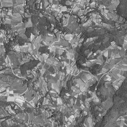




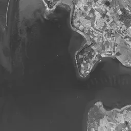




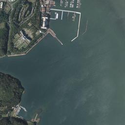
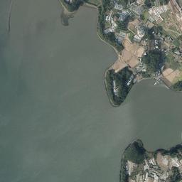






Center photograph taken: 1962-69
What to compare in this era: The strip-shaped lots in the center, and the water surface of the inlet reaching in just south of them. The terraced fields on the hill to the left are also worth a look
Controls: drag to move / right-drag to rotate and tilt / scroll while holding ⌘ or Ctrl to zoomControls: slide with two fingers to move / pinch to zoom / drag two fingers up or down to tilt
Note: the 3D elevation data is based on current surveys, not on the terrain at the time of the photograph. Elevation tiles: processed from GSI Tiles
The 3D view could not be loaded. Check your connection and try again.
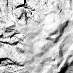
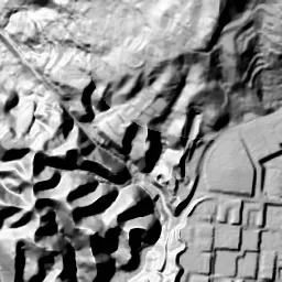
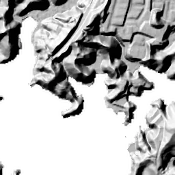
Note: the terrain shading is based on current surveys, not on the terrain at the time of the photograph. Hillshade map: processed from GSI Tiles
Note: the map is today's, not a map from the time of the photograph. Map: © OpenStreetMap contributors
Source: processed from GSI Tiles (aerial photographs by era / latest nationwide photographs / single photographs)
Explore this area on the mapMove the map to compare the surroundings then and now as well.
Overlay and compare the 1961-1969 aerial photograph and today's photograph of the Huis Ten Bosch (Hario) area, Nagasaki Prefecture. All photographs are published by the Geospatial Information Authority of Japan (GSI).
Eras of photographs for this location
For the Huis Ten Bosch (Hario) area, aerial photographs from the following eras can be compared.
The old photographs of this location cover 2 eras from 1961-1969 to 1974-1978; as of 2026, the newest photograph, 1974-1978, is 51 years ago.There are no photographs of this location from after that until today. The differences between eras are summarized in the guide to aerial photograph eras.
Coverage for each era differs by region. Only the eras that actually have photographs of this location are listed here.
Elevation of this location
The elevation (above sea level) at the reference point of Huis Ten Bosch (Hario) is 2.2 m (source: GSI elevation API). Elevation profiles running east-west and north-south through this location are also shown.
Profile positions (vertical green line = north-south / horizontal blue line = east-west)
Where the line in a profile breaks off and leaves a gap, no elevation data is available (water surfaces such as the sea or rivers).
Elevation is the value at the ground surface (even where a station is underground or elevated, the value is for the ground surface). Elevation is only one factor in disaster preparedness. Check actual risks such as flooding on the Hazard Map Portal Site and the hazard maps published by local governments.
Elevation tiles for the profiles: processed from GSI Tiles
Access by rail
One of the nearest stations to Huis Ten Bosch (Hario) is Huis Ten Bosch Station, served by the following lines.
- JR Kyushu Omura Line
Source of line information: processed from National Land Numerical Information (Railway Data / Ministry of Land, Infrastructure, Transport and Tourism).
Change seen in the share of built-up area
This compares land use in 1976 and 2021. The share of built-up area within 500 m changed from 0% to 45%. Among the locations on this site, the spread of built-up area here is on the large side (top 20-40%). The bar below shows where this location falls in the distribution across the locations on this site.
Source: processed from National Land Numerical Information (Land Use Subdivision Mesh / 1976 and 2021 / Ministry of Land, Infrastructure, Transport and Tourism). The texture value (amount of fine detail) of the photographs changed from 19.9 to 35.5. This is a mechanical comparison between photographs and includes differences from the shooting season and from black and white versus color, so treat it only as a rough guide.
Official land prices over time
The official land price (Chika Koji) standard site nearest to this location is "320-1 Jozen-cho, Sasebo, Nagasaki Prefecture" (about 2.9 km in a straight line; use: Residential). The official prices per square meter at this standard site from 1988 to 2026 are shown below. The 2026 official price is 15,000 yen.
View as a table
| Year | Official price |
|---|---|
| 1988 | 15,500 yen |
| 1989 | 15,700 yen |
| 1990 | 15,800 yen |
| 1991 | 16,700 yen |
| 1992 | 17,700 yen |
| 1993 | 18,100 yen |
| 1994 | 18,500 yen |
| 1995 | 18,800 yen |
| 1996 | 19,500 yen |
| 1997 | 19,900 yen |
| 1998 | 20,400 yen |
| 1999 | 20,800 yen |
| 2000 | 21,200 yen |
| 2001 | 21,200 yen |
| 2002 | 21,200 yen |
| 2003 | 21,200 yen |
| 2004 | 21,000 yen |
| 2005 | 20,800 yen |
| 2006 | 20,600 yen |
| 2007 | 20,400 yen |
| 2008 | 20,200 yen |
| 2009 | 19,600 yen |
| 2010 | 18,900 yen |
| 2011 | 18,200 yen |
| 2012 | 17,500 yen |
| 2013 | 16,900 yen |
| 2014 | 16,500 yen |
| 2015 | 16,100 yen |
| 2016 | 15,800 yen |
| 2017 | 15,600 yen |
| 2018 | 15,500 yen |
| 2019 | 15,400 yen |
| 2020 | 15,300 yen |
| 2021 | 15,200 yen |
| 2022 | 15,100 yen |
| 2023 | 15,000 yen |
| 2024 | 14,900 yen |
| 2025 | 14,900 yen |
| 2026 | 15,000 yen |
Source: processed from National Land Numerical Information (Land Price Publication Data / Ministry of Land, Infrastructure, Transport and Tourism). Official land prices are values published for standard sites as of January 1 each year and do not show the transaction price of any particular piece of land. The selection and location of standard sites may be reviewed from year to year.
Nearby locations
Sorted by distance from Huis Ten Bosch. Comparing them together shows how the same area has changed over time.
Select a marker on the map to see the location name and a link to it.
Locations with the same origins
Towns in the same category as Huis Ten Bosch (Reclaimed land), chosen from other regions. You can compare what they share in land use and town layout.
Select a marker on the map to see the location name and a link to it.
Recently viewed towns
This history is saved only on your device and is not sent to any server. Depending on your browser settings, it may be deleted automatically if you do not visit for a while (it is less likely to be deleted if you use the site as an app).
Why not look at how another town has changed?
History of Huis Ten Bosch (Hario)
The frame is set at a position where the entire park grounds of Huis Ten Bosch fit in the center. In exchange for fitting the blocks, the canals and even the boat basin into one frame, only two eras of past aerial photographs remain. Moreover, both of those two images show the place before the park grounds were born. This is a location where simply going back and forth between the eras shows that the surface in the center was remade twice.
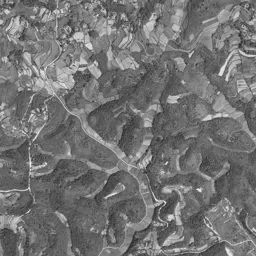
The place is the northern tip of Hario Island, on the west bank of the Haiki Strait. The Haiki Strait is a narrow waterway linking Sasebo Bay and Omura Bay, and in the photographs it appears as a band running from the upper right down to the bottom. The elevation of the measurement point in the center is 2.2 m, and even the eastern point is 2.9 m, so the numbers show that this is low flat land along the waterway. In contrast, the west rises to 15.8 m and the north to 14.2 m. The southern point is 6.0 m, but this is a value taken not from fine laser survey but from a coarse grid. It is terrain where hills closely surround low flat land, and the width of the flat part is narrower than you might think.
Strip fields and an inlet
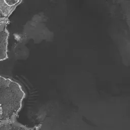
In the 1961-69 monochrome photograph, long, narrow strip-shaped lots line up diagonally in the center. It is land that was used as fields, several white roads cross it, and buildings are scattered as dots at their corners. Just south of the lots, a dark water surface reaches in and occupies the lower half of the frame. It is an inlet. The north and east shores of the inlet are divided off by straight lines, and near the eastern water's edge, low land divided into a grid juts out. The left half is a hill of forest and terraced fields, with a small settlement in each valley. In the middle right, a bridge across the strait appears, and on the east bank the straight lines of a road and a railway run side by side. A band of light color spreads on the upstream side of the strait and looks like a shallow bottom exposed by the ebbing tide. Several thin rows like the teeth of a comb float on the water surface in the lower corner. They look like equipment for growing something. On the west shore of the inlet, the forest presses up to the water's edge, and a thin white road follows the shore and passes south. In the lower left corner of the frame, a small cape covered with trees juts out into the water.
A pale surface of land preparation only
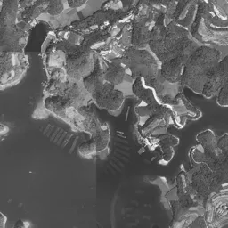
If you switch to the 1974-78 photograph, both the field lots in the center and the northern half of the inlet are gone. A uniformly pale surface spreads out, and the outline of the water's edge bends in straight lines and right angles. It is land whose shape was decided by people. Within the surface, woods left uncut remain as masses, and a small pond shines blue-green. Faint lot lines have been drawn, but almost no buildings appear. It looks like a state where work stopped once the land preparation was finished. Along the northern edge of the surface, brown bare ground and rectangular lots continue, and the color of soil is strong only there. The southern half of the inlet remains a dark green water surface, which also shows that the reclamation was not completed all at once. Note that in the composite of this era, the depth of color changes at the seams. Even under the same era label, it was not all taken in a single shoot, so the parts that look pale and hazy are differences in exposure and are not necessarily bare ground.
Ten-odd years of only the vessel
The park opened in 1992. The name means house in the woods in Dutch, and comes from the name of a palace of the Dutch royal family. Kamichika Yoshikuni, who had opened Nagasaki Holland Village on the Nishisonogi Peninsula in 1983, chose this flat land as his next stage. The pale surface in the 1974-78 photograph corresponds to that stage while it was not yet used for anything. Going back and forth between the two eras, you see in succession the ten-odd years in which only the vessel was prepared and nothing was put inside.
The nearest station is Huis Ten Bosch Station on the Omura Line, partway along the tracks running on the east bank of the strait. The name of the park has become the name of the station as it is. In the 1961-69 photograph too, those tracks appear as a thin straight line on the east bank. Both the tracks and the main road are on the east side of the strait, and the flat land on the west bank is entered by crossing a bridge. This arrangement does not change in the two past eras either.
Blocks held by canals
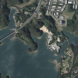
In the latest aerial photograph, the same surface has become a town. In the center, a circular plaza, a pond and a large domed building line up, and east of them houses with red roofs form rows. Canals run branching between the rows of houses, and small boats are lined up tightly on the dead-end water surfaces. At the southern water's edge, white floating landing piers jut out in the shape of a comb, and a long, narrow breakwater juts out into the bay. On the west side, large flat-roofed buildings and wide parking lots gather, and a road in a cutting crosses the edge of the hill. A flat surface divided into fine rows spreads on the east bank of the strait. On the upstream side of the strait, bridges are set at short intervals, and roads flank both sides of the waterway. Meanwhile, the hill on the left keeps the same pattern of terraced fields as in 1961-69, showing that only the low flat land was remade.
If you compare it with the pale surface of 1974-78, you can see that the bends of the water's edge remain in almost the same positions in the latest photograph too. This means that the blocks were placed as they were on top of the outline drawn at the time of land preparation. The landmark to use when comparing is the line of the water's edge that reaches south from the center. In 1961-69 the water reaches deep into the inlet, in 1974-78 it bends in straight lines and recedes, and in the latest photograph floating landing piers and a breakwater line up there. The same single line is drawn in a different shape in each era.
The record of official land prices (Chika Koji) that can be referred to is a single residential site in Shiroma-cho, about 2.9 km away. Per square meter it rose from 15,500 yen in 1988 to 21,200 yen in 2000, and in the 2026 publication it is 15,000 yen. The lowest in the records up to the 2026 publication is 14,900 yen in 2024, and 2025 also stays at the same value. It is not land inside the park grounds, so it cannot be read directly as the value of the park. Even so, the movement in which the surrounding residential land rose once over the thirty-odd years since the opening and has fallen since then can be read.
The elevation numbers show directly that this is low flat land. To check how far water is assumed to come in a storm surge or tsunami, consult the City of Sasebo's flood assumption map. If you open it after checking the water's edge before reclamation in the aerial photographs, its color coding takes on a different meaning.
Flat land made by filling in the sea can also be compared at Heiwajima / Oi Pier.