Nankodai / Asahigaoka about 60 years ago and today
Then and now


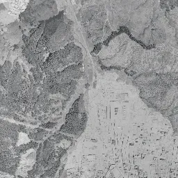


Center photograph taken: 1961-68
What to compare in this era: The white grid that appeared on the hill in the right half. If you compare it with the left half, where woods and fields still remain, you can tell from which side the development advanced
Controls: drag to move / right-drag to rotate and tilt / scroll while holding ⌘ or Ctrl to zoomControls: slide with two fingers to move / pinch to zoom / drag two fingers up or down to tilt
This 3D terrain is today's. The mismatch when you overlay an old photograph is the evidence of the land development that cut hills and filled valleys.
Note: the 3D elevation data is based on current surveys, not on the terrain at the time of the photograph. Elevation tiles: processed from GSI Tiles
The 3D view could not be loaded. Check your connection and try again.
Gray areas in the old photograph: Areas where no aerial photograph of this era is available (outside the area photographed, over the sea and the like).
Note: the terrain shading is based on current surveys, not on the terrain at the time of the photograph. Hillshade map: processed from GSI Tiles
Note: the map is today's, not a map from the time of the photograph. Map: © OpenStreetMap contributors
Source: processed from GSI Tiles (aerial photographs by era / latest nationwide photographs / single photographs)
Explore this area on the mapMove the map to compare the surroundings then and now as well.
Overlay and compare the 1961-1969 aerial photograph and today's photograph of the Nankodai / Asahigaoka area, Miyagi Prefecture. All photographs are published by the Geospatial Information Authority of Japan (GSI).
Eras of photographs for this location
For the Nankodai / Asahigaoka area, aerial photographs from the following eras can be compared.
The old photographs of this location cover 4 eras from 1945-1950 to 1984-1986; as of 2026, the newest photograph, 1984-1986, is 42 years ago.There are no photographs of this location from after that until today. The differences between eras are summarized in the guide to aerial photograph eras.
Coverage for each era differs by region. Only the eras that actually have photographs of this location are listed here.
Elevation of this location
The elevation (above sea level) near Asahigaoka Station is 44.7 m (source: GSI elevation API). Elevation profiles running east-west and north-south through this location are also shown.
Profile positions (vertical green line = north-south / horizontal blue line = east-west)
Elevation is the value at the ground surface (even where a station is underground or elevated, the value is for the ground surface). Elevation is only one factor in disaster preparedness. Check actual risks such as flooding on the Hazard Map Portal Site and the hazard maps published by local governments.
Elevation tiles for the profiles: processed from GSI Tiles
Access by rail
Asahigaoka Station is served by the following lines.
- Sendai Subway Namboku Line
Source of line information: processed from National Land Numerical Information (Railway Data / Ministry of Land, Infrastructure, Transport and Tourism).
Change seen in the share of built-up area
This compares land use in 1976 and 2021. The share of built-up area within 500 m changed from 44% to 55%. Among the locations on this site, the spread of built-up area here is on the small side (bottom 20-40%). The bar below shows where this location falls in the distribution across the locations on this site.
Source: processed from National Land Numerical Information (Land Use Subdivision Mesh / 1976 and 2021 / Ministry of Land, Infrastructure, Transport and Tourism). The texture value (amount of fine detail) of the photographs changed from 14.5 to 33.7. This is a mechanical comparison between photographs and includes differences from the shooting season and from black and white versus color, so treat it only as a rough guide.
Official land prices over time
The official land price (Chika Koji) standard site nearest to this location is "3-61-63 Asahigaoka, Aoba Ward, Sendai, Miyagi Prefecture" (about 320 m in a straight line; use: Residential). The official prices per square meter at this standard site from 2021 to 2026 are shown below. The 2026 official price is 169,000 yen.
View as a table
| Year | Official price |
|---|---|
| 2021 | 120,000 yen |
| 2022 | 125,000 yen |
| 2023 | 131,000 yen |
| 2024 | 147,000 yen |
| 2025 | 159,000 yen |
| 2026 | 169,000 yen |
Source: processed from National Land Numerical Information (Land Price Publication Data / Ministry of Land, Infrastructure, Transport and Tourism). Official land prices are values published for standard sites as of January 1 each year and do not show the transaction price of any particular piece of land. The selection and location of standard sites may be reviewed from year to year.
Nearby locations
Sorted by distance from Nankodai / Asahigaoka. Comparing them together shows how the same area has changed over time.
Select a marker on the map to see the location name and a link to it.
Locations with the same origins
Towns in the same category as Nankodai / Asahigaoka (New town), chosen from other regions. You can compare what they share in land use and town layout.
Select a marker on the map to see the location name and a link to it.
Recently viewed towns
This history is saved only on your device and is not sent to any server. Depending on your browser settings, it may be deleted automatically if you do not visit for a while (it is less likely to be deleted if you use the site as an app).
Why not look at how another town has changed?
History of Nankodai / Asahigaoka
If you open the latest aerial photograph, a single dark green mass remaining in the midst of hills densely lined with roofs catches the eye. Even the tree-covered ridges and the shadows of the valleys cutting into them can be seen clearly, and both its color and the fineness of its surface are completely different from the residential areas around it. Asahigaoka Station is at the eastern foot of that green. Of the measuring points in the four directions, only the southern 40.8 m is below the central 44.7 m, while the west at 54.7 m, the east at 54.1 m and the north at 51.4 m are all 6 to 10 m higher. The values show terrain in which the station was placed near the floor of a valley running south, between the wooded hill and the hill of the residential area on the east side.
The town area of Sendai spreads over flat terraces made by the Hirose River, but north of it is land where hills 40 to 60 m high undulate, with ridges and valleys alternating at short intervals. Water was too scarce to open paddies and the flat surfaces were fragmented, so for a long time it was a place where woods, fields and valley-floor paddies were mixed. But by the time the population grew and the town area overflowed northward, this relief worked to its advantage instead. If the earth from cutting the tops of the ridges was dropped into the valleys, surfaces on which lots could be lined up could be taken out without limit. The names Nankodai and Asahigaoka both have a bright ring pointing to the heights of the hills.
A photograph of only the southern half
The oldest photograph, from 1945-50, shows only the south side of the frame. The northern half has no image, and the boundary runs in a single horizontal line, with gray blank space beyond. The area around the station is also on the blank side, so its appearance in this era is unknown. In the range that is shown, the hills are covered with woods, narrow valleys enter them like branches, and on the valley floors long, narrow paddies continue inward, stacking up in tiers. Small clusters of houses are placed here and there along the valleys, and bright thin lines linking them trace the valley lines. Only the lower left corner of the frame looks different, where a town area densely packed with streets and buildings comes in. This means the northern edge of Sendai's town area just reached the corner of this frame. Within that town area, a dark water surface and a section where long, narrow buildings form rows facing the same way can also be made out. From the top of the hills toward the town area, a single white road descends diagonally. In front of the town area a single long, narrow straight strip of open ground runs diagonally, and beyond it a cluster of buildings and open ground can be seen.
A grid drawn on the hills
In the 1961-69 photograph, a fine white grid appears on the hills in the right half of the frame. Small roofs line up along the lot lines, and the residential area spreads as if using up the flat part of the hill to its edges. The outline is not square but goes in and out like inlets to fit the shape of the ridges. The town picked the flat surfaces of the hills to sit on. The surroundings are still woods, a black, winding water surface has gathered in the northern valley, and thin stripes of fields and farmhouses remain on the eastern hill. In the left half, bright field lots and woods alternate, and a white north-south road descends the hill and enters the town area in the lower left. Bare ground that seems to be mid-development can also be seen here and there, the largest toward the top of the frame, with streaks of cutting marks running across the bare earth. At the southern end of the residential area there is a cluster of buildings holding a wide sports ground, with a small dark pond just east of it. It is an era in which before and after the making of the town are divided diagonally within a single photograph.
Ridges and valleys filled with roofs
By the 1974-78 photograph, the same frame is almost filled with housing. In the upper right, lots so fine that the houses look a size smaller cover the slopes, and streets branch and extend like the ribs of a fan. Even the valley lines that were woods and fields in 1961-69 are filled with roofs. Even so, the green in the center remained. Surrounded by residential land, the woods rise abruptly at the outline, and inside, the shadows of the valleys fall darkly. The hill that was not cut remains with its outline intact. Only the southern half of the forest is a brighter green, and the boundary where the tone changes runs in a straight line. This is where two photographs meet. In the upper left the traces of cutting the hills are wide, and a broad band crosses the white bare earth, from which you can read that road works are going ahead.
The 1984-86 photograph falls in the season when the trees have lost their leaves, and the notches of ridges and valleys inside the forest can be seen better than in the previous era. On its northern edge, a wide straight structure spans the valley east-west, and the earthworks for its approaches continue. Along the eastern edge too there is a long, narrow north-south band of works, with square open ground and what look like temporary huts lined up along the way. On the residential side, the small pieces of open ground that had remained between lots are filled one after another, and at the right edge a sports facility with red-surfaced courts can also be made out. In 1987 the Sendai Subway Namboku Line opened, and a station was built at Asahigaoka. However, because the tracks run underground, they do not appear in the photographs taken from above. The year the skeleton of the town changed appears in the photographs only as the replacement of buildings around the station, and that is also a highlight of this location.
A hill town that kept its forest
In the latest photograph, buildings with large roofs gather at the eastern foot of the green, and next to them a turf-colored sports ground shines as a square. This is the area in front of the station, and if you set it beside the fine roofs of the residential area, the size of each single roof is different at a glance. The east-west road that was under construction in 1984-86 passes as a single straight line to the right edge of the frame, and the buildings along it line up evenly. The road along the eastern edge of the forest has also taken a form that can be driven through. The fan-shaped streets in the right half keep the same form as in 1974-78, and the only change is the roof colors of rebuilt houses. Woods remain like islands on valley floors and steep slopes, and school sports grounds and the green spaces of parks also make open places here and there among the continuous roofs. The area of the black water surface that filled the northern valley in 1961-69 remains as a green hollow surrounded by houses.
In the residential land of Asahigaoka 3-chome, the official land price (Chika Koji) at a point about 320 m from the location is recorded as 120,000 yen per square meter in 2021 and 169,000 yen in 2026. The remaining record covers only 2021 to 2026, values from after the town made by cutting the hills had passed half a century. Land made by cutting ridges and land made by filling valleys differ in how the ground was formed, and the boundary between them can be roughly estimated by going back through the eras of the photographs and comparing. However, you cannot infer the disaster assumptions themselves from the photographs. The City of Sendai's hazard map shows the assumptions for each district. You cannot tell from the photographs anything beyond the history of the land, and for anything further there is no choice but to rely on that map.