Toyama Station North (Fugan Canal Kansui Park) about 60 years ago and today
Then and now
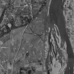
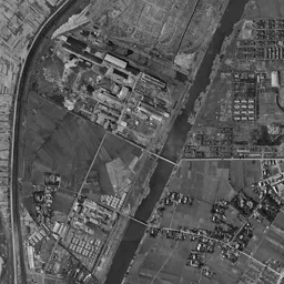
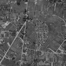


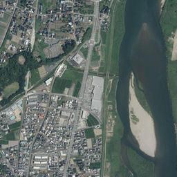
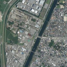
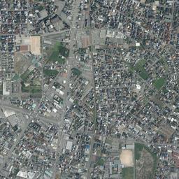




Center photograph taken: 1961-67
What to compare in this era: If you follow the dark line entering from the top edge of the frame, you reach a water surface that widens in the center and dead-ends roundly. That is the southern end of the canal
Controls: drag to move / right-drag to rotate and tilt / scroll while holding ⌘ or Ctrl to zoomControls: slide with two fingers to move / pinch to zoom / drag two fingers up or down to tilt
Note: the 3D elevation data is based on current surveys, not on the terrain at the time of the photograph. Elevation tiles: processed from GSI Tiles
The 3D view could not be loaded. Check your connection and try again.
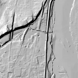
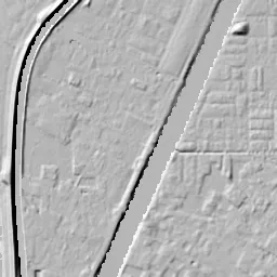
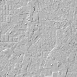
Note: the terrain shading is based on current surveys, not on the terrain at the time of the photograph. Hillshade map: processed from GSI Tiles
Note: the map is today's, not a map from the time of the photograph. Map: © OpenStreetMap contributors
Source: processed from GSI Tiles (aerial photographs by era / aerial photographs by fiscal year / latest nationwide photographs / single photographs / survey periods of the photographs)
Explore this area on the mapMove the map to compare the surroundings then and now as well.
Overlay and compare the 1961-1969 aerial photograph and today's photograph of the Toyama Station North (Fugan Canal Kansui Park) area, Toyama Prefecture. All photographs are published by the Geospatial Information Authority of Japan (GSI).
Eras of photographs for this location
For the Toyama Station North (Fugan Canal Kansui Park) area, aerial photographs from the following eras can be compared.
The old photographs of this location cover 3 eras from 1961-1969 to FY2007; as of 2026, the newest photograph, FY2007, is 18-19 years ago.There are no photographs of this location from after that until today. The differences between eras are summarized in the guide to aerial photograph eras.
Coverage for each era differs by region. Only the eras that actually have photographs of this location are listed here.
Elevation of this location
The elevation (above sea level) at the reference point of Toyama Station North (Fugan Canal Kansui Park) is 6.0 m (source: GSI elevation API). Elevation profiles running east-west and north-south through this location are also shown.
Profile positions (vertical green line = north-south / horizontal blue line = east-west)
Elevation is the value at the ground surface (even where a station is underground or elevated, the value is for the ground surface). Elevation is only one factor in disaster preparedness. Check actual risks such as flooding on the Hazard Map Portal Site and the hazard maps published by local governments.
Elevation tiles for the profiles: processed from GSI Tiles
Access by rail
One of the nearest stations to Toyama Station North (Fugan Canal Kansui Park) is Toyama Station, served by the following lines.
- JR West Takayama Line
- Ainokaze Toyama Railway Line
- JR West Hokuriku Shinkansen
Source of line information: processed from National Land Numerical Information (Railway Data / Ministry of Land, Infrastructure, Transport and Tourism).
Change seen in the share of built-up area
This compares land use in 1976 and 2021. The share of built-up area within 500 m changed from 86% to 82%. Among the locations on this site, the spread of built-up area here is among the smallest (bottom 20%). The bar below shows where this location falls in the distribution across the locations on this site.
Source: processed from National Land Numerical Information (Land Use Subdivision Mesh / 1976 and 2021 / Ministry of Land, Infrastructure, Transport and Tourism). The texture value (amount of fine detail) of the photographs changed from 14.6 to 37.2. This is a mechanical comparison between photographs and includes differences from the shooting season and from black and white versus color, so treat it only as a rough guide.
Official land prices over time
The official land price (Chika Koji) standard site nearest to this location is "1-38 Okuda-kotobuki-machi Okegawa, Toyama, Toyama Prefecture" (about 519 m in a straight line; use: Residential). The official prices per square meter at this standard site from 1983 to 2026 are shown below. The 2026 official price is 110,000 yen.
View as a table
| Year | Official price |
|---|---|
| 1983 | 107,000 yen |
| 1984 | 111,000 yen |
| 1985 | 115,000 yen |
| 1986 | 119,000 yen |
| 1987 | 123,000 yen |
| 1988 | 128,000 yen |
| 1989 | 138,000 yen |
| 1990 | 162,000 yen |
| 1991 | 200,000 yen |
| 1992 | 215,000 yen |
| 1993 | 215,000 yen |
| 1994 | 197,000 yen |
| 1995 | 190,000 yen |
| 1996 | 173,000 yen |
| 1997 | 172,000 yen |
| 1998 | 165,000 yen |
| 1999 | 155,000 yen |
| 2000 | 147,000 yen |
| 2001 | 138,000 yen |
| 2002 | 123,000 yen |
| 2003 | 108,000 yen |
| 2004 | 94,000 yen |
| 2005 | 85,800 yen |
| 2006 | 82,000 yen |
| 2007 | 81,000 yen |
| 2008 | 81,000 yen |
| 2009 | 80,000 yen |
| 2010 | 78,000 yen |
| 2011 | 75,500 yen |
| 2012 | 74,200 yen |
| 2013 | 73,000 yen |
| 2014 | 72,000 yen |
| 2015 | 73,500 yen |
| 2016 | 76,000 yen |
| 2017 | 79,500 yen |
| 2018 | 81,500 yen |
| 2019 | 85,000 yen |
| 2020 | 90,000 yen |
| 2021 | 91,000 yen |
| 2022 | 94,000 yen |
| 2023 | 98,000 yen |
| 2024 | 102,000 yen |
| 2025 | 106,000 yen |
| 2026 | 110,000 yen |
Source: processed from National Land Numerical Information (Land Price Publication Data / Ministry of Land, Infrastructure, Transport and Tourism). Official land prices are values published for standard sites as of January 1 each year and do not show the transaction price of any particular piece of land. The selection and location of standard sites may be reviewed from year to year.
Nearby locations
Sorted by distance from Toyama Station North. Comparing them together shows how the same area has changed over time.
Select a marker on the map to see the location name and a link to it.
Locations with the same origins
Towns in the same category as Toyama Station North (Former factory site), chosen from other regions. You can compare what they share in land use and town layout.
Select a marker on the map to see the location name and a link to it.
Articles that feature this location
Recently viewed towns
This history is saved only on your device and is not sent to any server. Depending on your browser settings, it may be deleted automatically if you do not visit for a while (it is less likely to be deleted if you use the site as an app).
Why not look at how another town has changed?
History of Toyama Station North (Fugan Canal Kansui Park)
A long, narrow water surface lies in the center of the frame; a large white roof sits at its southern end, and an elevated station extends east-west further south. This is the north side of Toyama Station in the City of Toyama, Toyama Prefecture. If you open the aerial photographs from the oldest era, this water surface appears not as a place for walking but as a place for transferring cargo. A single canal entering from the top edge of the frame swells in the center and dead-ends there. On the left the Jinzu River flows past a chain of wide riverbeds, and toward the bottom dozens of tracks spread east in a bundle. Land that was a knot between water transport and the railway has turned into a place for walking by the water.
Moving the river and digging a canal
The town area of Toyama opened on the left bank of the Jinzu River, but the river meandered close past the edge of the town and flooded the town area at every high water. From the early 1900s, works to shorten its course went ahead, and the river moved west, away from the town. A wide former riverbed that kept its curve but had lost its water was left behind. A long, narrow low marshy strip came to lie in the very middle of the town area, and dealing with it became the next task.
The answer chosen was a plan to dig a canal north of the town area and connect the port and the station by waterway. In the 1930s the Fugan Canal was dug, and the dug-out earth was carried away as earth for filling the former river land. This means that the reclamation and the digging of the canal were organized as a single work. The southern end of the canal was placed on the north side of the station, and a wide basin was made for ships to turn around and transfer cargo. That water surface, called a boat basin (funadamari), is in the center of the frame. Because there is a difference in water level between it and the side nearer the sea, a device that raises and lowers the water level to let ships pass was installed partway along. A canal is a structure that ships cannot pass through just by digging it.
The boat basin and the bundle of tracks
In the black-and-white 1961-69 photograph, the canal enters from the top edge as a thin dark line, runs straight south, and widens in the center. The water surface is wide in the north and, narrowing toward the south, dead-ends roundly at the boat basin. On the west bank, long, narrow buildings and short lots continue as a band, and rows of thin stripe-like fields spread outside them. The east bank is large rectangular farmland, with rows of trees dotted along the boundaries. In the upper half of the frame, many buildings with long roofs lie on the west bank of the canal, and between them small parallel shapes are packed like the teeth of a comb.
Toward the bottom of the frame is a bundle of tracks spreading into dozens heading east from the station. Between the lines short rows of dots can be seen, freight cars left standing as grains. Just north of the bundle, a single bright building with an oval outline catches the eye. A round plaza where roads gather radially lies south of the station, and a grid of town area divided by wide straight roads lies beyond it. The right bank of the Jinzu River is fields and scattered settlements, and only two bridges cross the river within the frame.
1974-78 is the first era with color at this location. The shape of the canal's water surface hardly changes, but the colors around it are replaced. The factory zone on the west bank has more roofs, and equipment with round outlines also appears. On the east bank, streets have been drawn through what was rectangular farmland, and it has turned into a residential area where small roofs line up regularly. East of the boat basin a wide, bright area of ground lies open, and a sports ground where an oval track surrounds a green rectangle also appears. The bundle of tracks is wider than in the previous era, with many lines drawn on faded ground. On the Jinzu River, white sandbars spread widely, and the flow of water is narrowed into thin bands between the bars.
The decision to keep the water surface
The cargo transport that the canal carried was replaced by roads and motor vehicles. Once both materials and products travel over land, the waterway is left unused. Filling in an unused water surface to make land was the path chosen in many places in this period. Since a wide flat area is born in the very middle of the town area, it can be used for both roads and buildings. Toyama did not do this, and kept the water surface without filling it in. Once a water surface is filled in, it cannot be returned to what it was. This is because digging it again takes the effort of moving the same amount of earth, and the years during which water filled it cannot themselves be made again. The boat basin and part of the canal were laid out as a park at the width they had when they were dug. From the late 1990s, lawn and paths were laid at the water's edge, and bridges across the water and a landing for boats were placed, so the water surface could be followed by boat. This means that equipment for carrying cargo is used as it is as the framework of the scenery. In the same prefecture, a place where the shape of the water surface decided the use of the land is Toyama Shinko Port.
The elevated station and the waterside park
In today's photograph, both banks of the central water surface are edged with green, and lawn surfaces, curving paths and thin bridges crossing the water can be made out. On the west bank there is a small round plaza, and paths radiate from it. The canal entering from the northern edge is straight, and its width and direction overlap exactly with the 1961-69 photograph. A building with a large white roof stands at the southern end of the water surface, and a long elevated roof lies south of it. The Shinkansen opened in 2015, and the station of the conventional lines was also raised onto an elevated structure at that time. In 2020 the north and south streetcar lines were connected under the elevated structure, and the town that had been divided at the station has become continuous. The station yard that spread north of the station has been reduced to a few lines, and buildings and parking lots have come into the freed-up space.
The difference in height among the five measuring points is only 1.7 m. The highest is 6.6 m in the north and the lowest is 4.9 m in the west; the center is 6.0 m, and the south and east are both 6.2 m. Only the west is low because that is the side that slopes down toward the riverbed of the Jinzu River. It is flat land near the lower end of an alluvial fan, and the slope is not enough to follow with the eye. Since this land lies between the Jinzu River and the canal, for flood assumptions it is good to compare the differences between the river side and the canal side on the hazard maps published by Toyama Prefecture and the City of Toyama.
In a residential area of Okuda-kotobuki-machi, about 519 m from this location, there is a survey point with a long price record. From 107,000 yen per square meter in 1983 it kept rising, and in 1992 and 1993 it reached 215,000 yen, the highest value on record up to the 2026 publication of the official land prices (Chika Koji). From there came a long decline, and 72,000 yen in 2014 is the lowest up to the 2026 publication. After that it turned upward, and in the 2026 publication it is 110,000 yen. The beginning and end of the record line up at almost the same height, making the shape of a single round trip.
If you switch between the two eras of 1961-69 and 1974-78 and today, you can see that the use of the land was replaced and the shape of the water remained. The tracks, the factories and the farmland all changed their appearance, but the outline of the water surface dug in the 1930s can be found in common in all three photographs. Neither the reason for digging the canal nor the reason for lining up dozens of tracks remains today. Even so, because the dug shape remained, this land continues to be described as a town of water. Even when the reason for digging is lost, the dug shape remains in the land.