Yumenoshima / Shinkiba about 60 years ago and today
Then and now


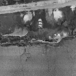


Center photograph taken: 1961-66
What to compare in this era: The straight lines of the white seawalls enclosing the southern lot. Note that the inside of the enclosure is still water surface
Controls: drag to move / right-drag to rotate and tilt / scroll while holding ⌘ or Ctrl to zoomControls: slide with two fingers to move / pinch to zoom / drag two fingers up or down to tilt
Note: the 3D elevation data is based on current surveys, not on the terrain at the time of the photograph. Elevation tiles: processed from GSI Tiles
The 3D view could not be loaded. Check your connection and try again.
Gray areas in the old photograph: Areas where no aerial photograph of this era is available (outside the area photographed, over the sea and the like).
Note: the terrain shading is based on current surveys, not on the terrain at the time of the photograph. Hillshade map: processed from GSI Tiles
Note: the map is today's, not a map from the time of the photograph. Map: © OpenStreetMap contributors
Source: processed from GSI Tiles (aerial photographs by era / latest nationwide photographs / single photographs)
Explore this area on the mapMove the map to compare the surroundings then and now as well.
Overlay and compare the 1961-1969 aerial photograph and today's photograph of the Yumenoshima / Shinkiba area, Tokyo. All photographs are published by the Geospatial Information Authority of Japan (GSI).
Eras of photographs for this location
For the Yumenoshima / Shinkiba area, aerial photographs from the following eras can be compared.
The old photographs of this location cover 7 eras from c. 1936-1942 to 1987-1990; as of 2026, the newest photograph, 1987-1990, is 37 years ago.There are no photographs of this location from after that until today. The differences between eras are summarized in the guide to aerial photograph eras.
Coverage for each era differs by region. Only the eras that actually have photographs of this location are listed here.
Elevation of this location
The elevation (above sea level) near Shin-kiba Station is 5.2 m (source: GSI elevation API). Elevation profiles running east-west and north-south through this location are also shown.
Profile positions (vertical green line = north-south / horizontal blue line = east-west)
Where the line in a profile breaks off and leaves a gap, no elevation data is available (water surfaces such as the sea or rivers).
Elevation is the value at the ground surface (even where a station is underground or elevated, the value is for the ground surface). Elevation is only one factor in disaster preparedness. Check actual risks such as flooding on the Hazard Map Portal Site and the hazard maps published by local governments.
Elevation tiles for the profiles: processed from GSI Tiles
Access by rail
Shin-kiba Station is served by the following lines.
- Tokyo Metro Yurakucho Line
- Rinkai Line
- JR East Keiyo Line
Source of line information: processed from National Land Numerical Information (Railway Data / Ministry of Land, Infrastructure, Transport and Tourism).
Change seen in the share of built-up area
This compares land use in 1976 and 2021. The share of built-up area within 500 m changed from 0% to 51%. Among the locations on this site, the spread of built-up area here is on the large side (top 20-40%). The bar below shows where this location falls in the distribution across the locations on this site.
Source: processed from National Land Numerical Information (Land Use Subdivision Mesh / 1976 and 2021 / Ministry of Land, Infrastructure, Transport and Tourism). The texture value (amount of fine detail) of the photographs changed from 17.8 to 45.2. This is a mechanical comparison between photographs and includes differences from the shooting season and from black and white versus color, so treat it only as a rough guide.
Official land prices over time
The official land price (Chika Koji) standard site nearest to this location is "1-1-13 Tatsumi, Koto Ward, Tokyo" (about 1.9 km in a straight line; use: Residential). The official prices per square meter at this standard site from 2013 to 2026 are shown below. The 2026 official price is 694,000 yen.
View as a table
| Year | Official price |
|---|---|
| 2013 | 354,000 yen |
| 2014 | 364,000 yen |
| 2015 | 372,000 yen |
| 2016 | 383,000 yen |
| 2017 | 399,000 yen |
| 2018 | 413,000 yen |
| 2019 | 447,000 yen |
| 2020 | 475,000 yen |
| 2021 | 475,000 yen |
| 2022 | 498,000 yen |
| 2023 | 523,000 yen |
| 2024 | 555,000 yen |
| 2025 | 611,000 yen |
| 2026 | 694,000 yen |
Source: processed from National Land Numerical Information (Land Price Publication Data / Ministry of Land, Infrastructure, Transport and Tourism). Official land prices are values published for standard sites as of January 1 each year and do not show the transaction price of any particular piece of land. The selection and location of standard sites may be reviewed from year to year.
Nearby locations
Sorted by distance from Yumenoshima / Shinkiba. Comparing them together shows how the same area has changed over time.
Select a marker on the map to see the location name and a link to it.
Locations with the same origins
Towns in the same category as Yumenoshima / Shinkiba (Reclaimed land), chosen from other regions. You can compare what they share in land use and town layout.
Select a marker on the map to see the location name and a link to it.
Articles that feature this location
Places that used to be sea. Trace reclaimed land through aerial photographs and maps
How to read old aerial photographs: how to use Kakomap
60 years of the Tokyo Bay shore: the changing purposes of reclamation
Where did the rafts of the timber storage ponds disappear first? Old photographs of Shinkiba, Ariake, and Toyosu
How an artificial island differs from reclaimed land: photographs of Port Island, Daiba, and others
Does the Keiyo Line run on reclaimed land? Old photographs from Shinkiba to Chiba Minato
Recently viewed towns
This history is saved only on your device and is not sent to any server. Depending on your browser settings, it may be deleted automatically if you do not visit for a while (it is less likely to be deleted if you use the site as an app).
Why not look at how another town has changed?
History of Yumenoshima / Shinkiba
Yumenoshima and Shinkiba are land made later on top of the shallow sea at the inner end of Tokyo Bay. The front of the river mouths, where sediment carried by the rivers had made the water shallow, was suited to being turned into land by bringing in earth and waste by ship. There was also a reason why a timber town moved here. The basic way to store logs is to keep them floating in the water, and that needs a wide water surface gathered in one place. Along the inland canals there was no longer enough room to keep rafts, and sawmilling and the timber trade moved together from Kiba in Fukagawa. The place name Shinkiba (the name means new Kiba) is this move turned directly into a name.
A square floating on the sea
If you switch to the aerial photograph from around 1936-42, almost all of the range for which photographs are available is sea surface. Many striped patterns of shoals run over the water, and the shapes of the sand left by the ebbing tide remain as they were. Land divided by straight lines and a water surface enclosed in a square by a white rim appear only in the upper left corner. Small white dots are scattered inside the enclosure, which suggests that there too the water surface was partitioned and something was floated on it. The places with no photograph at all are three lots on the southeast side and one lot in the southwest, which remain as gray blank space. The island is nowhere yet.
In the 1945-50 photograph, a sharp-cornered square island appears in the center of the frame. The inside of the island is not uniform, with whitish fill and black puddles mixed in patches, and it looks like works stopped partway. It is surrounded by sea on all four sides, and no road or bridge crossing to the island can be seen. At the left edge, a grid of streets and canals lines up, and only that part is a town area connected to the mainland. The history, in which reclamation began before the war under a plan to build an airfield and the works were stopped by the war, overlaps well with this uneven outline of the island.
Only the seawalls first
In the 1961-69 photograph, the outline of the island has grown greatly to the north. In the northern lot, small mounds of piled-up earth and waste and bare work roads threading between them spread out, and the roughness of the surface comes through even across the grain of the photograph. In this period, the place was used as a final disposal site for garbage and was known by the name Yumenoshima.
The southern lot in the same photograph looks completely different. White straight seawalls have finished enclosing the sea in a square, yet the inside is still water surface, with patches of deposits floating only here and there. The outer frame first, the contents later. From the lower half to the right half of the frame, an expanse of rippling sea continues, and neither the lines of seawalls nor the lines of roads enter it. At the left edge, across a canal, large white buildings that seem to be factories are placed, and to their north the streets divide finely and the rows of roofs grow dense. From this difference in density you can read from which side the front line of reclamation extended.
Logs lined up on the water
By 1974-78 the photograph is in color, and the use of the enclosed water surface can be understood at a glance. Wooden rafts line up neatly in the ponds, and brown rectangles cover the water surface like a grid. On the land side, piles of timber laid down make stripes, and straight roads and wide bare ground just created divide them. In the lower left of the frame there is the same group of rafts, and the way the water surface is used continues outside the frame. Outside the eastern seawall, a row of small stakes juts out into the sea. At the southern end a bridge and the straight line of the road continuing from it come in, and along the northern edge a factory with a blue roof and finely divided roofs of houses appear. The water surface itself is the facility.
By 1979-83, gabled roofs begin to line up along the edges of the ponds. White and blue-green buildings form rows around the ponds, and the timber rafts fill the water surface almost without gaps. In the northern lot the development of a park is advancing, and an oval track, a round structure and paths edged with rows of trees can be made out. A wide elevated band crossing the frame straight east-west also shows clearly from this era. The water surfaces to the east and south are muddy brown, and even outside the seawalls the color of the water comes close to that of the land.
Ponds that became empty
In the 1984-86 photograph, the pond in the lower center is black and empty. Rafts remain in the upper and middle ponds, and the pond in the lower left is still filled as before, so you can tell that the use and crowding differed from pond to pond. Along the eastern edge, newly leveled bare ground and a green sports ground have been added.
In the 1987-90 photograph the rafts cover the water surface again, and the density as a timber storage pond is at its highest. Two east-west elevated structures run side by side and pass across the water to the opposite bank at the eastern end. In the southeast too, a row of bridge supports is rising. The tracks and roads arrived together. In 1988 two lines reached this island, a third was added later, and as of 2026 it is a station where three lines gather: the Yurakucho Line / the Keiyo Line / the Rinkai Line.
The method of storing timber floating in the water became less necessary as imports brought in as raw logs dwindled. Wood processed into boards and square timber could simply be piled up under a roof, and there was no longer a reason to hold a wide water surface. The emptying of the ponds is the result of this trend, and in the photographs it happens with a time lag from pond to pond.
If you switch to today's photograph, the timber has vanished from the water surface of the ponds. Only dashed frames marking the lots remain on the water, and the surroundings are covered completely by the roofs of warehouses and factories. The ponds kept only their outlines. In the park to the north, a stadium with a red track and a lawn plaza sit side by side, and on the water beyond, white ships are moored tightly to landing piers. The east-west band has become a corridor where several railway lines and elevated roads stand shoulder to shoulder, crossing the water of the mouth of the Arakawa River at the eastern end. A long, narrow green band continues along the seawalls, and the water of the river mouth lies outside it. Timber rafts remain here and there only in the pond in the lower left.
Even if you switch to the elevation cross-section, there is almost no relief either east-west or north-south. The central measuring point is 5.2 m, the lowest, south and west, are 4.7 m, and the highest, north, is 5.6 m, so the difference does not reach 1 m. It is the cross-section of land made by leveling flat on top of the water. The official land price (Chika Koji) point is in Tatsumi 1-chome, Koto Ward, about 1.9 km from here, and it is recorded as residential land. The records per square meter begin at 354,000 yen in 2013 and reach 694,000 yen in the 2026 official land prices, roughly doubling from 2013 to the 2026 official land prices. The assumptions for flooding on low land are published by the local government in the form of maps, so if you are involved with this area through your home or work, it is a good idea to keep the map distributed by Koto Ward at hand and check it.