Toyosu about 60 years ago and today
Then and now


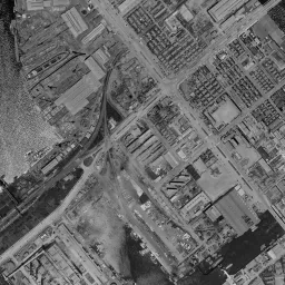


Nearby single photograph taken: June 26, 1963 (0.4 km from this spot)
What to compare in this era: The long, narrow structures sloping diagonally down to the water's edge toward the left of the frame are slipways. If you compare them with the commercial facility in the same position in today's photograph, you notice that the shape of the waterside has been carried on
Controls: drag to move / right-drag to rotate and tilt / scroll while holding ⌘ or Ctrl to zoomControls: slide with two fingers to move / pinch to zoom / drag two fingers up or down to tilt
Note: the 3D elevation data is based on current surveys, not on the terrain at the time of the photograph. Elevation tiles: processed from GSI Tiles
The 3D view could not be loaded. Check your connection and try again.
Note: the terrain shading is based on current surveys, not on the terrain at the time of the photograph. Hillshade map: processed from GSI Tiles
Note: the map is today's, not a map from the time of the photograph. Map: © OpenStreetMap contributors
Source: processed from GSI Tiles (aerial photographs by era / latest nationwide photographs / single photographs)
Explore this area on the mapMove the map to compare the surroundings then and now as well.
Overlay and compare the 1961-1969 aerial photograph and today's photograph of the Toyosu area, Tokyo. All photographs are published by the Geospatial Information Authority of Japan (GSI).
Eras of photographs for this location
For the Toyosu area, aerial photographs from the following eras can be compared.
The old photographs of this location cover 7 eras from c. 1936-1942 to 1987-1990; as of 2026, the newest photograph, 1987-1990, is 37 years ago.There are no photographs of this location from after that until today. The differences between eras are summarized in the guide to aerial photograph eras.
Coverage for each era differs by region. Only the eras that actually have photographs of this location are listed here.
Elevation of this location
The elevation (above sea level) near Toyosu Station is 2.4 m (source: GSI elevation API). Elevation profiles running east-west and north-south through this location are also shown.
Profile positions (vertical green line = north-south / horizontal blue line = east-west)
Where the line in a profile breaks off and leaves a gap, no elevation data is available (water surfaces such as the sea or rivers).
Elevation is the value at the ground surface (even where a station is underground or elevated, the value is for the ground surface). Elevation is only one factor in disaster preparedness. Check actual risks such as flooding on the Hazard Map Portal Site and the hazard maps published by local governments.
Elevation tiles for the profiles: processed from GSI Tiles
Access by rail
Toyosu Station is served by the following lines.
- Yurikamome Line
- Tokyo Metro Yurakucho Line
Source of line information: processed from National Land Numerical Information (Railway Data / Ministry of Land, Infrastructure, Transport and Tourism).
Change seen in the share of built-up area
This compares land use in 1976 and 2021. The share of built-up area within 500 m changed from 53% to 78%. Among the locations on this site, the spread of built-up area here is in the middle. The bar below shows where this location falls in the distribution across the locations on this site.
Source: processed from National Land Numerical Information (Land Use Subdivision Mesh / 1976 and 2021 / Ministry of Land, Infrastructure, Transport and Tourism). The texture value (amount of fine detail) of the photographs changed from 16.8 to 40.7. This is a mechanical comparison between photographs and includes differences from the shooting season and from black and white versus color, so treat it only as a rough guide.
Official land prices over time
The official land price (Chika Koji) standard site nearest to this location is "4-3-11 Toyosu, Koto Ward, Tokyo" (about 470 m in a straight line; use: Residential). The official prices per square meter at this standard site from 2012 to 2026 are shown below. The 2026 official price is 1,160,000 yen.
View as a table
| Year | Official price |
|---|---|
| 2012 | 429,000 yen |
| 2013 | 441,000 yen |
| 2014 | 479,000 yen |
| 2015 | 515,000 yen |
| 2016 | 556,000 yen |
| 2017 | 600,000 yen |
| 2018 | 640,000 yen |
| 2019 | 690,000 yen |
| 2020 | 730,000 yen |
| 2021 | 730,000 yen |
| 2022 | 770,000 yen |
| 2023 | 820,000 yen |
| 2024 | 880,000 yen |
| 2025 | 1,000,000 yen |
| 2026 | 1,160,000 yen |
Source: processed from National Land Numerical Information (Land Price Publication Data / Ministry of Land, Infrastructure, Transport and Tourism). Official land prices are values published for standard sites as of January 1 each year and do not show the transaction price of any particular piece of land. The selection and location of standard sites may be reviewed from year to year.
Nearby locations
Sorted by distance from Toyosu. Comparing them together shows how the same area has changed over time.
Select a marker on the map to see the location name and a link to it.
Locations with the same origins
Towns in the same category as Toyosu (Reclaimed land), chosen from other regions. You can compare what they share in land use and town layout.
Select a marker on the map to see the location name and a link to it.
Articles that feature this location
Places that used to be sea. Trace reclaimed land through aerial photographs and maps
How to read old aerial photographs: how to use Kakomap
60 years of the Tokyo Bay shore: the changing purposes of reclamation
Where did the rafts of the timber storage ponds disappear first? Old photographs of Shinkiba, Ariake, and Toyosu
Recently viewed towns
This history is saved only on your device and is not sent to any server. Depending on your browser settings, it may be deleted automatically if you do not visit for a while (it is less likely to be deleted if you use the site as an app).
Why not look at how another town has changed?
History of Toyosu
The port of Tokyo opened onto a shallow sea filled in by sediment carried by the Sumida River. Large ships could not come close to the shore, and for a long time cargo handling in Tokyo meant moving cargo from a ship anchored offshore onto lighters and carrying it to the riverside landings along the rivers. The only way to modernize the port was to dig the channels deeper, and the dug-out sediment, needing somewhere to go, was piled into the shallow sea. Toyosu is land born out of that work. The place name too was newly given as the reclamation advanced, and it is said to express the hope that the land would grow into a rich sandbank. This square land has no old settlement to inherit and no natural terrain to trace. It is not land where roads came through after a town formed, but land where lines were drawn on a nautical chart, the inside of the lines was filled with sediment, a grid of roads was laid first, and then factories and warehouses were brought in.
Land where the grid came first
The photograph from around 1936-42 shows that order just as it is. A long, narrow piece of land cut apart on all sides by canals lies in the center of the frame; inside it only a grid of roads has been drawn, and many of the lots are still white ground with nothing built. In the northwestern corner the existing town area presses close as fine rows of houses, and the contrast with the newly lined-out reclaimed land stands out. From the lower left of the frame along the bottom edge is water everywhere, crossed by only a single thin line of seawall. On the right, long factory buildings line up, and white smoke rises. At the lower right a pale trapezoid with only an outline floats, telling that the reclamation is still under way.
In 1945-50, just after the end of the war, the empty lots fill with rows of buildings with long gabled roofs. Toward the north, long, narrow buildings of the same shape line up neatly, and from the way the roofs are arranged you can read that they are a group of warehouses or factories handling materials. Meanwhile the southern half of the frame is still wide water, with places where the shallows show through white. On that water, long, narrow jetties extend out away from the land. The land had begun to work as an industrial island, but the land preparation on the bay side was not yet finished.
An island of slipways and storage tanks
The 1961-69 photograph, shown by default, captures the time when this island was at its most industrial. Almost the whole frame is filled with factories and warehouses, material yards and quays, and small boats loaded with cargo line the canals. Toward the left of the frame, many long, narrow structures sloping diagonally down toward the water's edge can be seen. These are slipways for assembling ship hulls and lowering them into the water. This corner was occupied by the shipyard of Ishikawajima-Harima Heavy Industries, which is also the site that becomes the centerpiece of the later redevelopment. Long, narrow sections that seem to be timber bound into rafts float on the water in front of it, appearing as stripes as they catch the light. Toward the bottom of the frame, several round storage tanks line up, showing that equipment handling fuel and raw materials occupied the area. It was not a place where people came for a walk but a working site where steel, timber and fuel moved.
Even if you move on through 1974-78, 1979-83 and 1984-86, the outline cut by the canals itself hardly moves. Only the contents move. On the water in 1974-78, timber rafts are packed tightly, and in 1979-83 those sections are still intact, covering the water as brown bands. In 1984-86 the area of the rafts visibly shrinks, and open water spreads. The group of round storage tanks stays in the same place through the three eras, and at the lower right of the frame an elevated road appears and crosses diagonally. The process by which a form of logistics, floating timber on water to store it and carrying it by ship, headed toward its end remains as a change in the way the water surface was used.
In the 1987-90 photograph, the rafts have almost disappeared from the water. Inside the outline, warehouses with blue roofs and wide paving begin to stand out, and toward the top of the frame a wide area of bare ground with nothing built appears. The site the factories have left is waiting for its next use, and this blank later becomes the base for high-rise housing and commercial facilities. The round storage tanks still remain; these are the few years when the island of heavy industry and the town waiting for redevelopment lived together in the same frame.
The town the railway drew in
It was the railway that decided the character of the town. In 1988 Toyosu Station on the subway Yurakucho Line opened, connecting it directly to the city center. In 2006 the Yurikamome Line was extended to Toyosu Station, and it became a transfer station where lines from two directions meet. In the same year, 2006, Urban Dock LaLaport Toyosu opened on the former site of the shipyard. The word dock in the name comes from the fact that this site was a place for building ships. In October 2018 Toyosu Market opened, moved from Tsukiji. A site where a Tokyo Gas plant had long operated was replaced by huge buildings handling seafood. University campuses and high-rise offices also gathered around the station, and it became a town where morning and evening commuting and weekend shopping flow in separate time slots.
In the photograph as of 2026, a cluster of super-high-rise buildings casting shadows stands in the center of the frame, and a long, narrow green band continues along the bottom edge. The water on the left remains without being filled in, and a bridge crosses it diagonally. The outline of the reclamation is almost unchanged from the photograph from around 1936-42, and the lines drawn by that time still decide the boundaries of the blocks and the direction of the roads. On the LaLaport site, a large crane used at the shipyard has been kept, conveying the history of the place where shoppers walk. In the official land prices (Chika Koji), a residential site in Toyosu 4-chome, a few hundred meters from the station, went from 429,000 yen per square meter in 2012 to 1,160,000 yen in the 2026 publication, about 2.7 times. The elevation is 2.4 m at the measuring point near the station, 3.1 m on the south side, 2.1 m in the north and the east, and 5.4 m at the measuring point on the west side, so the height of the ground differs slightly depending on when it was reclaimed and what the land preparation was for. Setting out its history year by year gives the following.
When you switch the photographs, turning your eyes to the following places makes the changes easier to read.