Daiba about 60 years ago and today
Then and now


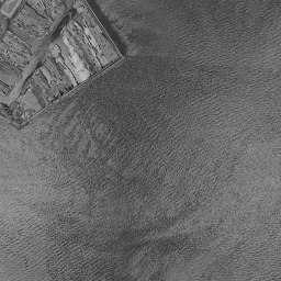


Nearby single photograph taken: June 26, 1963 (0.2 km from this spot)
What to compare in this era: A thin straight line crosses the water on the south side of the frame. It is a seawall that enclosed the lots before reclamation, and if you move forward to 1974-78, the inside has become land
Controls: drag to move / right-drag to rotate and tilt / scroll while holding ⌘ or Ctrl to zoomControls: slide with two fingers to move / pinch to zoom / drag two fingers up or down to tilt
Note: the 3D elevation data is based on current surveys, not on the terrain at the time of the photograph. Elevation tiles: processed from GSI Tiles
The 3D view could not be loaded. Check your connection and try again.
Gray areas in the old photograph: Areas where no aerial photograph of this era is available (outside the area photographed, over the sea and the like).
Note: the terrain shading is based on current surveys, not on the terrain at the time of the photograph. Hillshade map: processed from GSI Tiles
Note: the map is today's, not a map from the time of the photograph. Map: © OpenStreetMap contributors
Source: processed from GSI Tiles (aerial photographs by era / latest nationwide photographs / single photographs)
Explore this area on the mapMove the map to compare the surroundings then and now as well.
Overlay and compare the 1961-1969 aerial photograph and today's photograph of the Daiba area, Tokyo. All photographs are published by the Geospatial Information Authority of Japan (GSI).
Eras of photographs for this location
For the Daiba area, aerial photographs from the following eras can be compared.
The old photographs of this location cover 7 eras from c. 1936-1942 to 1987-1990; as of 2026, the newest photograph, 1987-1990, is 37 years ago.There are no photographs of this location from after that until today. The differences between eras are summarized in the guide to aerial photograph eras.
Coverage for each era differs by region. Only the eras that actually have photographs of this location are listed here.
Elevation of this location
The elevation (above sea level) near Daiba Station is 5.8 m (source: GSI elevation API). Elevation profiles running east-west and north-south through this location are also shown.
Profile positions (vertical green line = north-south / horizontal blue line = east-west)
Where the line in a profile breaks off and leaves a gap, no elevation data is available (water surfaces such as the sea or rivers).
Elevation is the value at the ground surface (even where a station is underground or elevated, the value is for the ground surface). Elevation is only one factor in disaster preparedness. Check actual risks such as flooding on the Hazard Map Portal Site and the hazard maps published by local governments.
Elevation tiles for the profiles: processed from GSI Tiles
Access by rail
Daiba Station is served by the following lines.
- Yurikamome Line
Source of line information: processed from National Land Numerical Information (Railway Data / Ministry of Land, Infrastructure, Transport and Tourism).
Change seen in the share of built-up area
This compares land use in 1976 and 2021. The share of built-up area within 500 m changed from 0% to 39%. Among the locations on this site, the spread of built-up area here is on the large side (top 20-40%). The bar below shows where this location falls in the distribution across the locations on this site.
Source: processed from National Land Numerical Information (Land Use Subdivision Mesh / 1976 and 2021 / Ministry of Land, Infrastructure, Transport and Tourism). The texture value (amount of fine detail) of the photographs changed from 10.6 to 32.7. This is a mechanical comparison between photographs and includes differences from the shooting season and from black and white versus color, so treat it only as a rough guide.
Official land prices over time
The official land price (Chika Koji) standard site nearest to this location is "3-1-160 and adjacent lots, Ariake, Koto Ward, Tokyo" (about 1.7 km in a straight line; use: Retail, Office, Warehouse). The official prices per square meter at this standard site from 2007 to 2026 are shown below. The 2026 official price is 1,430,000 yen.
View as a table
| Year | Official price |
|---|---|
| 2007 | 1,050,000 yen |
| 2008 | 1,200,000 yen |
| 2009 | 1,160,000 yen |
| 2010 | 1,090,000 yen |
| 2011 | 998,000 yen |
| 2012 | 947,000 yen |
| 2013 | 928,000 yen |
| 2014 | 953,000 yen |
| 2015 | 970,000 yen |
| 2016 | 997,000 yen |
| 2017 | 1,030,000 yen |
| 2018 | 1,100,000 yen |
| 2019 | 1,170,000 yen |
| 2020 | 1,250,000 yen |
| 2021 | 1,210,000 yen |
| 2022 | 1,230,000 yen |
| 2023 | 1,270,000 yen |
| 2024 | 1,300,000 yen |
| 2025 | 1,340,000 yen |
| 2026 | 1,430,000 yen |
Source: processed from National Land Numerical Information (Land Price Publication Data / Ministry of Land, Infrastructure, Transport and Tourism). Official land prices are values published for standard sites as of January 1 each year and do not show the transaction price of any particular piece of land. The selection and location of standard sites may be reviewed from year to year.
Nearby locations
Sorted by distance from Daiba. Comparing them together shows how the same area has changed over time.
Select a marker on the map to see the location name and a link to it.
Locations with the same origins
Towns in the same category as Daiba (Reclaimed land), chosen from other regions. You can compare what they share in land use and town layout.
Select a marker on the map to see the location name and a link to it.
Articles that feature this location
Places that used to be sea. Trace reclaimed land through aerial photographs and maps
How to read old aerial photographs: how to use Kakomap
60 years of the Tokyo Bay shore: the changing purposes of reclamation
Former sites of regional expositions. Portopia, the Yokohama Exposition, and Yokatopia as they once were
How an artificial island differs from reclaimed land: photographs of Port Island, Daiba, and others
Recently viewed towns
This history is saved only on your device and is not sent to any server. Depending on your browser settings, it may be deleted automatically if you do not visit for a while (it is less likely to be deleted if you use the site as an app).
Why not look at how another town has changed?
History of Daiba
In June 1853, Perry's fleet came to Uraga. The inner part of Edo Bay was shallow, and large warships could only follow a limited number of deep channels. The shogunate decided to build gun batteries on the sea that would fire on those channels from the side, and entrusted the design to Egawa Hidetatsu, the magistrate of Nirayama in Izu. Construction began in August of the same year, with a plan to line up eleven batteries off Shinagawa. Earth was dug from Gotenyama and Yatsuyama and carried by boat, and stone was shipped out from Izu. In the following year, 1854, the No. 1, No. 2 and No. 3 Daiba were finished, followed by the completion of No. 5 and No. 6. However, costs swelled, and with tension easing after the Japan-US Treaty of Peace and Amity was concluded, the rest were canceled. The strange terrain of square islands lined up like stepping stones on the sea is the product of this interrupted national defense project. The place name Daiba is also this word for a gun battery, left just as it was.
Batteries left behind in the sea
In the photograph from around 1936-42, most of the frame is sea. Several square islands float toward the top, and from one of them a long, straight jetty extends toward the land in the upper right. Only the upper right corner is land enclosed by angular seawalls, with roads and buildings. The lower right is outside the range of the photograph and is blacked out. In the 1945-50 photograph, the outlines of the islands become clear. On the square edges the ridgelines of earthen embankments can be seen, and inside there are shadows that look like structures. Left of the center, a long, narrow capsule-like island lies diagonally. The land in the upper right is dense with buildings and roads, and ships are moored at the quays. Even after about ninety years had passed since their construction, the islands of Daiba remained left behind on the sea.
Even in the 1961-69 photograph, which is shown by default, the lower half of the frame is still a uniform water surface. The change has begun from the edges. At the left edge a long, narrow band of reclaimed land lined with warehouses extends, and in the center a wedge-shaped piece of land with many thin jetties juts out. The eastern square island still has its short jetty extending northeast, and a pale island with no vegetation floats next to it on the west. Comparing it with the c. 1936-42 photograph, you notice that the number of square islands has decreased. From the Meiji era on, their role as gun batteries ended, and the remaining islands were demolished one after another in step with works to widen shipping routes and to reclaim land. The photographs record that decrease in the order of the eras. If you follow the frame south, a thin straight line crosses the water. It is the line of a seawall that encloses the lots for reclamation in advance. The method of Tokyo Port, drawing a line on the chart and filling the inside with earth and sand, had begun in this area too.
Reclaimed land left vacant
In the 1974-78 photograph, the inside of the line becomes land. The sand-colored flat land called Reclaimed Land No. 13 spreads from the center of the frame to the lower right, and only unpaved roads and curving access roads are drawn on it. Buildings are sparse, and large parts remain bare ground. In the inlet toward the top, small boats are tightly packed, filling the spaces between comb-like jetties. The islands of Daiba remain as small green squares, and the waterway left between them and the reclaimed land protected their outlines.
The two photographs of 1979-83 and 1984-86 capture the time when this bare ground stayed empty. The framework of the lots becomes more orderly with each era, parallel roads and park paths are drawn, and toward the south a green space of young trees and a round plaza appear. Even so, most of the site is brown vacant land, and buildings are limited to warehouses and cargo-handling facilities at the water's edge. In the 1984-86 photograph, an elevated road crosses the upper right of the frame diagonally, and warehouses with blue roofs line up in the lower right. On the sea a few kilometers from central Tokyo, such a wide blank stayed as it was for more than ten years.
The 1987-90 photograph shows a preview of the next era. On the north side of the islands of Daiba, square structures lined up at equal intervals and thin lines connecting them appear. It is the construction of the bridge that opened in 1993. Inside the reclaimed land, the green of grass has increased, and the trees in the green space toward the south have grown so that its shape can be made out. The Tokyo Metropolitan Government positioned this area as the Waterfront Subcenter and was advancing plans to run roads and railways through it.
The rise of a subcenter
Daiba as a district rose all at once in the 1990s. In August 1993 the Rainbow Bridge opened, linking the area by car with the Shibaura side. In November 1995 the Yurikamome Line opened, and it became possible to arrive from Shimbashi Station without changing trains. In the same year, 1995, the World City Expo was canceled; it had been planned with this area as its main venue. This was because a candidate who had promised cancellation won the election for governor of Tokyo, and the companies that had decided to move in and the prepared sites lost their destination. In 1996 Tokyo Teleport Station on the Rinkai Line opened, and in 1997 Fuji Television moved its headquarters from Kawadacho. Commercial facilities and a broadcaster came into the land left empty by the cancellation of the expo, and the subcenter became a place where people gather, in a form different from the original plan. In the late 1990s residents also began moving into housing, and it became a district where places to work, to play and to live sit on the same reclaimed land.
In the photograph as of 2026, a bridge crosses the top edge in an arc, and two square islands covered in green float in front of it. A narrow path leads to the eastern island from the land, while the western island is wrapped in trees with no path to approach it. The former is No. 3 Daiba, which was opened as a park after being designated a national Historic Site in the mid-1920s, and its earthen embankments and the remains of cooking stoves survive on the ground. The latter is No. 6 Daiba, which has remained an island of trees that cannot be landed on. No. 3 Daiba can be entered on foot by a narrow path laid across the water from the east side of the beach. On the reclaimed land side, high-rise hotels and commercial facilities, a broadcaster and a wide park line up, and a beach of brought-in sand fringes the water's edge. In the official land prices (Chika Koji), a commercial site in Ariake 3-chome, 1.7 km from the location, fell from 1,200,000 yen per square meter in 2008 to 928,000 yen in 2013, and recovered to 1,430,000 yen in the 2026 publication. The elevation is 5.8 m at the measuring point near the location and 4.5 m on the west side. The southern and eastern measuring points give negative values because they measure the water surface, and the northern measuring point is also only 0.6 m. The numbers also show that this is land open to the sea on three sides.
It is fun to look for the following places while you switch between eras.