Ariake about 60 years ago and today
Then and now


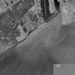


Nearby single photograph taken: November 4, 1966 (0.6 km from this spot)
What to compare in this era: Coarse black masses float tightly packed in the narrow waterways in the upper left of the frame. They are timber rafts. Even if you move on to 1987-90, the water in the upper left is still packed with rafts, and masses line the right edge too. In today's photograph only the strip-shaped water surfaces remain
Controls: drag to move / right-drag to rotate and tilt / scroll while holding ⌘ or Ctrl to zoomControls: slide with two fingers to move / pinch to zoom / drag two fingers up or down to tilt
Note: the 3D elevation data is based on current surveys, not on the terrain at the time of the photograph. Elevation tiles: processed from GSI Tiles
The 3D view could not be loaded. Check your connection and try again.
Gray areas in the old photograph: Areas where no aerial photograph of this era is available (outside the area photographed, over the sea and the like).
Note: the terrain shading is based on current surveys, not on the terrain at the time of the photograph. Hillshade map: processed from GSI Tiles
Note: the map is today's, not a map from the time of the photograph. Map: © OpenStreetMap contributors
Source: processed from GSI Tiles (aerial photographs by era / latest nationwide photographs / single photographs)
Explore this area on the mapMove the map to compare the surroundings then and now as well.
Overlay and compare the 1961-1969 aerial photograph and today's photograph of the Ariake area, Tokyo. All photographs are published by the Geospatial Information Authority of Japan (GSI).
Eras of photographs for this location
For the Ariake area, aerial photographs from the following eras can be compared.
The old photographs of this location cover 7 eras from c. 1936-1942 to 1987-1990; as of 2026, the newest photograph, 1987-1990, is 37 years ago.There are no photographs of this location from after that until today. The differences between eras are summarized in the guide to aerial photograph eras.
Coverage for each era differs by region. Only the eras that actually have photographs of this location are listed here.
Elevation of this location
The elevation (above sea level) near Ariake Station is 9.1 m (source: GSI elevation API). Elevation profiles running east-west and north-south through this location are also shown.
Profile positions (vertical green line = north-south / horizontal blue line = east-west)
Where the line in a profile breaks off and leaves a gap, no elevation data is available (water surfaces such as the sea or rivers).
Elevation is the value at the ground surface (even where a station is underground or elevated, the value is for the ground surface). Elevation is only one factor in disaster preparedness. Check actual risks such as flooding on the Hazard Map Portal Site and the hazard maps published by local governments.
Elevation tiles for the profiles: processed from GSI Tiles
Access by rail
Ariake Station is served by the following lines.
- Yurikamome Line
Source of line information: processed from National Land Numerical Information (Railway Data / Ministry of Land, Infrastructure, Transport and Tourism).
Change seen in the share of built-up area
This compares land use in 1976 and 2021. The share of built-up area within 500 m changed from 8% to 68%. Among the locations on this site, the spread of built-up area here is among the largest (top 20%). The bar below shows where this location falls in the distribution across the locations on this site.
Source: processed from National Land Numerical Information (Land Use Subdivision Mesh / 1976 and 2021 / Ministry of Land, Infrastructure, Transport and Tourism). The texture value (amount of fine detail) of the photographs changed from 14.7 to 36.5. This is a mechanical comparison between photographs and includes differences from the shooting season and from black and white versus color, so treat it only as a rough guide.
Official land prices over time
The official land price (Chika Koji) standard site nearest to this location is "3-1-160 and adjacent lots, Ariake, Koto Ward, Tokyo" (about 495 m in a straight line; use: Retail, Office, Warehouse). The official prices per square meter at this standard site from 2007 to 2026 are shown below. The 2026 official price is 1,430,000 yen.
View as a table
| Year | Official price |
|---|---|
| 2007 | 1,050,000 yen |
| 2008 | 1,200,000 yen |
| 2009 | 1,160,000 yen |
| 2010 | 1,090,000 yen |
| 2011 | 998,000 yen |
| 2012 | 947,000 yen |
| 2013 | 928,000 yen |
| 2014 | 953,000 yen |
| 2015 | 970,000 yen |
| 2016 | 997,000 yen |
| 2017 | 1,030,000 yen |
| 2018 | 1,100,000 yen |
| 2019 | 1,170,000 yen |
| 2020 | 1,250,000 yen |
| 2021 | 1,210,000 yen |
| 2022 | 1,230,000 yen |
| 2023 | 1,270,000 yen |
| 2024 | 1,300,000 yen |
| 2025 | 1,340,000 yen |
| 2026 | 1,430,000 yen |
Source: processed from National Land Numerical Information (Land Price Publication Data / Ministry of Land, Infrastructure, Transport and Tourism). Official land prices are values published for standard sites as of January 1 each year and do not show the transaction price of any particular piece of land. The selection and location of standard sites may be reviewed from year to year.
Nearby locations
Sorted by distance from Ariake. Comparing them together shows how the same area has changed over time.
Select a marker on the map to see the location name and a link to it.
Locations with the same origins
Towns in the same category as Ariake (Reclaimed land), chosen from other regions. You can compare what they share in land use and town layout.
Select a marker on the map to see the location name and a link to it.
Articles that feature this location
Recently viewed towns
This history is saved only on your device and is not sent to any server. Depending on your browser settings, it may be deleted automatically if you do not visit for a while (it is less likely to be deleted if you use the site as an app).
Why not look at how another town has changed?
History of Ariake
Ariake lies southeast of central Tokyo, where the mouth of the Sumida River opens onto the bay. It is the area where Ariake Station on the Yurikamome Line is located, and on the map it is drawn as a flat lot surrounded on all four sides by canals and bridges. But open the old aerial photographs and there is no district there. Most of the frame is water, and land worth the name appears only slightly at the edges. The name Ariake was also given after the reclamation had progressed, and no villages or roads from the Edo period can be traced. The story of this land begins with drawing a line on the sea.
A single line drawn on the sea
The c. 1936-42 photograph is almost entirely water. On the coarse-grained gray water surface, a single thin straight line runs from the upper part of the frame toward the left edge. It is the edge of a seawall or jetty, and this one line is the trace of human work. In the upper right corner there are two lots of white, mottled ground, recognizable as land already reclaimed. Faint angular outlines can be seen in the water, apparently the layout of lots that will become land. The lower right of the frame is outside the range of the photograph and is a gray blank.
In the 1945-50 photograph, a hook-shaped piece of land appears from the center of the frame to the lower left. Its surface is still mottled, scattered with dark dots that look like trees. Near the top edge, two or three long, narrow bands with white borders line up, looking like lots that divide the water to hold something. In the upper right, fine rows of houses are densely packed, with large buildings mixed in, and you can read that the city is pressing toward the bay. Right of the center there is a wide square enclosed by pale shores, dark and rough inside. The composite of this era has two missing tiles, which remain as gray squares in the lower part of the frame.
A water surface with floating rafts
It is in 1961-69 that the roofs of warehouses and factories cover the upper left half of the frame, and this is also the photograph the viewer opens first. Round storage tanks line up along the top edge, and in the narrow waterways between the buildings, coarse long, narrow black masses float tightly packed. These are lots where timber was bound into rafts, floated on the water and stored that way. The land on the right is still pale, dotted with vacant lots like black stains. And from the center of the frame to the lower right, it remains an expanse of water with visible lines of waves. The square area in the lower right that alone appears bright and smooth is a seam where photographs taken at different times were joined.
Graded land covered with grass
In 1974-78, when the photographs turn to color, the area from the center of the frame downward is transformed. Where the lines of waves were, there is now wide ocher bare ground. Only straight road lines are faintly drawn on the ground, and there are almost no buildings. The state in which the land was made but there was no district yet is captured in this photograph. The upper left is unchanged, with factories and white round storage tanks, and rafts line the water at the top center. The sea on the right is greenish, dotted with small ships and flat barges. Near the bottom edge, a few buildings with blue roofs can be seen.
By 1979-83, the color of the bare ground has changed to a dull green. This is because grass has grown everywhere, and the grid of roads can be read more clearly than in the previous era. The rafts on the water have actually increased, lining up as dark bands in the upper left and center of the frame and along the right edge. The sea does not appear uniformly; a water surface faded to brown and one sunk into navy switch at a seam of the photographs, and only the contrast with the grass-covered ground runs through the whole frame. From here, several eras follow in which the land was left as grassland, waiting for the district to come.
The way the diagonal line has grown catches the eye in 1984-86. The line running from the lower left of the frame to the upper right also appeared thinly in 1979-83, but in this era it has widened into a thick band of two lines side by side, and zooming in, you can even count the supports of the bridge crossing over the water. On graded land where no one lived, only the routes for passing through gained thickness first. The rafts are still there, and the grassland and grid of roads also remain as in the previous era.
In 1987-90 too, the band of roads still runs diagonally as two lines side by side, but from the center of the frame downward, a corner with dozens of long, narrow lots lined up in parallel newly appears. Toward the left there is a corner where a building with a round roof and rectangles painted in different colors are gathered, apparently a place for sports. Masses of rafts still remain at the right edge and in the upper left, and barges float on the water right of the center. The groundwork just before becoming a district is all present in this photograph.
An exhibition center and a high-rise district
Two things ended the time of grassland: a means of carrying people, and buildings that gather people. In 1995 the Yurikamome Line opened from Shimbashi Station to Ariake Station, linking it directly by rail with central Tokyo. The following year, 1996, the Tokyo International Exhibition Center opened. Known by the name Tokyo Big Sight, it led to more than ten thousand people getting off at Ariake for each trade fair and exhibition. With the station and the exhibition center opening one after another, the graded land broke out of being grassland with no set use. At the Tokyo 2020 Games, held in 2021, the newly built Ariake Arena was used as a competition venue, and it remains a venue for events after the Games.
In today's aerial photograph, high-rise buildings stand shoulder to shoulder in the center of the frame, all casting long, narrow shadows in the same direction. A wide road lined with street trees runs at their feet. Huge buildings with roofs of the same size lined up at equal intervals continue from the center downward. These are the exhibition halls. The elevated road runs diagonally as a thick band, and the ramps climbing up to it swirl. At the right edge there remains an area where long, narrow water surfaces line up like strips, conveying in outline only how the water was used when rafts were floated on it. The rows of factories and warehouses in the upper left have not changed position either, and a corner that has not changed and a corner that has share the same frame.
Even on the same reclaimed land, the height of the ground is not evenly flat. The measuring point near the station is the highest at 9.1 m, dropping to 7.2 m in the east, 6 m in the south and 5.1 m in the north, and the western measuring point is only 4.5 m. Differences in when it was reclaimed and what was meant to be placed there remain as steps of a few meters. To know how far water is assumed to reach, the hazard map published by Koto Ward is the reliable reference. The record of values, on the other hand, does not go back to the grassland era. There is a point placed for store / office / warehouse use in Ariake 3-chome, about 500 m away, where 1,050,000 yen per square meter in 2007 fell to 928,000 yen in 2013, and then 1,430,000 yen in 2026 is the highest in the series up to the 2026 publication.