Tennozu about 60 years ago and today
Then and now


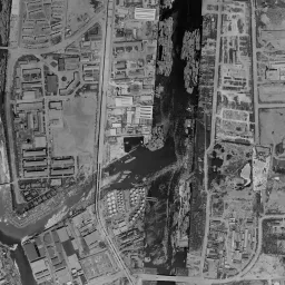


Nearby single photograph taken: June 26, 1963 (0.7 km from this spot)
What to compare in this era: A row of round tanks toward the north of the island and a row of square lighters in the eastern canal can be seen. The bridge crossing the canal to the east spans the same position in today's photograph too
Controls: drag to move / right-drag to rotate and tilt / scroll while holding ⌘ or Ctrl to zoomControls: slide with two fingers to move / pinch to zoom / drag two fingers up or down to tilt
Note: the 3D elevation data is based on current surveys, not on the terrain at the time of the photograph. Elevation tiles: processed from GSI Tiles
The 3D view could not be loaded. Check your connection and try again.
Note: the terrain shading is based on current surveys, not on the terrain at the time of the photograph. Hillshade map: processed from GSI Tiles
Note: the map is today's, not a map from the time of the photograph. Map: © OpenStreetMap contributors
Source: processed from GSI Tiles (aerial photographs by era / latest nationwide photographs / single photographs)
Explore this area on the mapMove the map to compare the surroundings then and now as well.
Overlay and compare the 1961-1969 aerial photograph and today's photograph of the Tennozu area, Tokyo. All photographs are published by the Geospatial Information Authority of Japan (GSI).
Eras of photographs for this location
For the Tennozu area, aerial photographs from the following eras can be compared.
The old photographs of this location cover 7 eras from c. 1936-1942 to 1987-1990; as of 2026, the newest photograph, 1987-1990, is 37 years ago.There are no photographs of this location from after that until today. The differences between eras are summarized in the guide to aerial photograph eras.
Coverage for each era differs by region. Only the eras that actually have photographs of this location are listed here.
Elevation of this location
The elevation (above sea level) near Tennozu Isle Station is 2.8 m (source: GSI elevation API). Elevation profiles running east-west and north-south through this location are also shown.
Profile positions (vertical green line = north-south / horizontal blue line = east-west)
Where the line in a profile breaks off and leaves a gap, no elevation data is available (water surfaces such as the sea or rivers).
Elevation is the value at the ground surface (even where a station is underground or elevated, the value is for the ground surface). Elevation is only one factor in disaster preparedness. Check actual risks such as flooding on the Hazard Map Portal Site and the hazard maps published by local governments.
Elevation tiles for the profiles: processed from GSI Tiles
Access by rail
Tennozu Isle Station is served by the following lines.
- Tokyo Monorail Haneda Airport Line
- Rinkai Line
Source of line information: processed from National Land Numerical Information (Railway Data / Ministry of Land, Infrastructure, Transport and Tourism).
Change seen in the share of built-up area
This compares land use in 1976 and 2021. The share of built-up area within 500 m changed from 41% to 53%. Among the locations on this site, the spread of built-up area here is in the middle. The bar below shows where this location falls in the distribution across the locations on this site.
Source: processed from National Land Numerical Information (Land Use Subdivision Mesh / 1976 and 2021 / Ministry of Land, Infrastructure, Transport and Tourism). The texture value (amount of fine detail) of the photographs changed from 19.6 to 38.3. This is a mechanical comparison between photographs and includes differences from the shooting season and from black and white versus color, so treat it only as a rough guide.
Official land prices over time
The official land price (Chika Koji) standard site nearest to this location is "1-299-3 Higashi-Shinagawa, Shinagawa Ward, Tokyo" (about 504 m in a straight line; use: Residential). The official prices per square meter at this standard site from 2013 to 2026 are shown below. The 2026 official price is 1,490,000 yen.
View as a table
| Year | Official price |
|---|---|
| 2013 | 700,000 yen |
| 2014 | 718,000 yen |
| 2015 | 738,000 yen |
| 2016 | 765,000 yen |
| 2017 | 794,000 yen |
| 2018 | 842,000 yen |
| 2019 | 895,000 yen |
| 2020 | 943,000 yen |
| 2021 | 943,000 yen |
| 2022 | 970,000 yen |
| 2023 | 1,020,000 yen |
| 2024 | 1,110,000 yen |
| 2025 | 1,260,000 yen |
| 2026 | 1,490,000 yen |
Source: processed from National Land Numerical Information (Land Price Publication Data / Ministry of Land, Infrastructure, Transport and Tourism). Official land prices are values published for standard sites as of January 1 each year and do not show the transaction price of any particular piece of land. The selection and location of standard sites may be reviewed from year to year.
Nearby locations
Sorted by distance from Tennozu. Comparing them together shows how the same area has changed over time.
Select a marker on the map to see the location name and a link to it.
Locations with the same origins
Towns in the same category as Tennozu (Reclaimed land), chosen from other regions. You can compare what they share in land use and town layout.
Select a marker on the map to see the location name and a link to it.
Articles that feature this location
Recently viewed towns
This history is saved only on your device and is not sent to any server. Depending on your browser settings, it may be deleted automatically if you do not visit for a while (it is less likely to be deleted if you use the site as an app).
Why not look at how another town has changed?
History of Tennozu
Tennozu is a rectangular island lying southeast of Shinagawa Station. It is surrounded by canals on all sides and is connected to the land only by bridges. The su in the name is a word for a shallow rise in the water, and in the Edo period this area was tidal flats and shallows spreading where the Meguro River flows out to the sea. At the end of the Edo period, gun batteries (daiba) were built off Shinagawa, and from the Meiji era into the 1920s the reclamation of Tokyo Bay went ahead. This island, which turned water into land, was given its shape from the start not as a place for people to live but as land for receiving cargo from ships.
Flat ground with nothing but seawalls
In the aerial photograph from around 1936-42, the outline of the island is already drawn in straight lines. A thin white band runs north-south along the eastern edge, and everything outside it is open sea. The area inside the band is flat ground with no streets or buildings, crossed only by a single thin diagonal line. At the northern end alone, a square lot appears darker than its surroundings, and small shadows cluster inside it. Several small square islands edged with straight lines float on the sea outside the island. They are the remains of the gun batteries built off Shinagawa at the end of the Edo period, and islands of the same origin also remain on the Daiba side. The seawall comes first, and the use is decided later. The order of time on reclaimed land is captured just as it is in this one photograph.
In 1945-50, the shape of the island becomes much easier to read. Its outline is a polygon with cut corners, and only the northeastern edge juts diagonally out into the sea. A single white road runs on the ground from the north side down to the southeast, bends partway, and passes through to the south. With that road as a backbone, long, narrow buildings appear on the northeast side in rows of a few each. On the southwest side, too, hut-like buildings gather facing the same way, but the ground between them stays wide and pale gray, with only the lines of the lots drawn faintly. On the water south of the island, many long, narrow white rows reach out toward the open sea. On the land to the west across the canal, roofs that look like warehouses stand densely, and the town area of Shinagawa and a bundle of tracks spreading like a fan continue behind them. A thin bridge spans the western canal, and the road connecting the island to the land can be confirmed. This shows a time when the far shore became busy before the island did.
An island of tanks and lighters
The 1961-69 photograph captures the time when the island was filled with industrial equipment. Toward the north, round storage tanks stand in rows, and if you count them, more than ten stand grouped together. In the middle, a wide lot that appears darker than its surroundings is left, and along the western edge long, narrow warehouses continue at regular intervals. In the eastern canal, square lighters are moored linked like beads on a string, stopped as if waiting for cargo. From the eastern edge of the island, a single bridge crosses the canal straight to the opposite shore. On the eastern bank of the canal, too, cylindrical tanks and long buildings line up, and you can read that the island and the opposite shore form one continuous industrial zone. On the water in the east of the frame, streak-like shadows spread in many layers, but you cannot tell what they are from the photograph alone.
Ground filling up with warehouses
The 1974-78 photograph is the first color aerial photograph at this island. The canal water appears deep green, and the boundary with the land is clearly divided. The northwestern half is packed tightly with long-roofed buildings. In the northeastern corner, things like white boxes are piled up finely, forming a pattern of even grains. Meanwhile, from the middle toward the south a large area of ocher bare ground remains, occupying almost the same place as the wide lot that appeared dark in the 1961-69 photograph. The difference in color shows directly that the land preparation of this island did not finish all at once. A long, narrow structure crossing the eastern part of the island diagonally runs in the same direction in this era too. On the east bank across the canal, round white tanks line up, still standing in the same positions as in 1961-69. Small boats float here and there on the water. In the 1979-83 photograph the water takes on an ocher tone, and the density of buildings rises further. In 1984-86 the water appears deep blue, and lighters are moored in a cluster in the western canal. By the 1987-90 photograph, the ground of the island can hardly be seen for the buildings and the piled-up boxes. If you compare the same lots across the four eras, you can read the order in which the buildings were rebuilt and grew larger.
The island where two stations came
It was the railway that changed the character of the island. In 1992 Tennozu Isle Station opened on the Tokyo Monorail Haneda Line, and a flow of people was added to the island of ships and freight. In 2001 a station on the Rinkai Line of Tokyo Waterfront Area Rapid Transit was also set up, so two sets of ticket gates came to stand side by side on the north side of the island. The practice of keeping warehouse buildings while replacing what is inside also spread, and buildings for storing cargo changed their role into places where people gather.
In the aerial photograph as of 2026, large office and mixed-use buildings gather in the northern half of the island, and a wide green space of lawn and trees opens in a corner to the south. An elevated structure runs north-south through the eastern edge, and the bridge that crossed the canal in 1961-69 has been replaced, in almost the same position, by a bridge with a blue frame. On the eastern pier across the canal, boxes of many colors stand in neat lines, and the high-rise buildings that grew up at the east exit of Shinagawa Station stand at the upper left of the frame. The looped approach of a bridge crossing the bay and a square island covered with trees are in the northeastern corner. The outline of the reclamation has hardly changed since around 1936-42, and the shape of the island itself is the oldest trace.
The ground height is 2.8 m at the measuring point in the center of the island. The south and the west are also 2.8 m, while the east is 3.8 m and the north is 4.6 m, slightly higher. The difference is about 2 m, and there is no relief that could be called a slope. It is low land surrounded by water. The assumptions for heavy rain and storm surges are shown on a map that Shinagawa Ward has colored by zone for each lot number. Check them against the positions of the buildings on the island that matter to you. As a clue to prices, there is a residential observation point for the official land prices (Chika Koji) in Higashi-Shinagawa 1-chome, about 500 m from the island. If you take the two ends of the record up to the 2026 publication, 2013 is 700,000 yen per square meter and 2026 is 1,490,000 yen.
Placing what happened in order of year gives the following.
As you move through the eras, keeping your eyes on the following places makes the changes easier to grasp.