Takanawa Gateway City about 60 years ago and today
Then and now


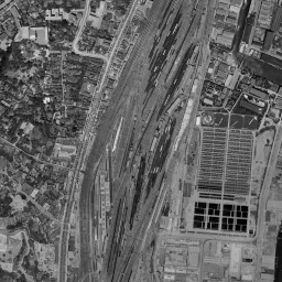


Nearby single photograph taken: June 26, 1963 (0.6 km from this spot)
What to compare in this era: East of the tracks there are two groups of water surfaces divided into grids. If you switch to today's photograph, the same place has become one large roof
Controls: drag to move / right-drag to rotate and tilt / scroll while holding ⌘ or Ctrl to zoomControls: slide with two fingers to move / pinch to zoom / drag two fingers up or down to tilt
Note: the 3D elevation data is based on current surveys, not on the terrain at the time of the photograph. Elevation tiles: processed from GSI Tiles
The 3D view could not be loaded. Check your connection and try again.
Note: the terrain shading is based on current surveys, not on the terrain at the time of the photograph. Hillshade map: processed from GSI Tiles
Note: the map is today's, not a map from the time of the photograph. Map: © OpenStreetMap contributors
Source: processed from GSI Tiles (aerial photographs by era / latest nationwide photographs / single photographs)
Explore this area on the mapMove the map to compare the surroundings then and now as well.
Overlay and compare the 1961-1969 aerial photograph and today's photograph of the Takanawa Gateway City area, Tokyo. All photographs are published by the Geospatial Information Authority of Japan (GSI).
Eras of photographs for this location
For the Takanawa Gateway City area, aerial photographs from the following eras can be compared.
The old photographs of this location cover 7 eras from c. 1936-1942 to 1987-1990; as of 2026, the newest photograph, 1987-1990, is 37 years ago.There are no photographs of this location from after that until today. The differences between eras are summarized in the guide to aerial photograph eras.
Coverage for each era differs by region. Only the eras that actually have photographs of this location are listed here.
Elevation of this location
The elevation (above sea level) near Takanawa Gateway Station is 3.4 m (source: GSI elevation API). Elevation profiles running east-west and north-south through this location are also shown.
Profile positions (vertical green line = north-south / horizontal blue line = east-west)
Elevation is the value at the ground surface (even where a station is underground or elevated, the value is for the ground surface). Elevation is only one factor in disaster preparedness. Check actual risks such as flooding on the Hazard Map Portal Site and the hazard maps published by local governments.
Elevation tiles for the profiles: processed from GSI Tiles
Access by rail
Takanawa Gateway Station is served by the following lines.
- JR East Tokaido Line
Source of line information: processed from National Land Numerical Information (Railway Data / Ministry of Land, Infrastructure, Transport and Tourism).
Change seen in the share of built-up area
This compares land use in 1976 and 2021. The share of built-up area within 500 m changed from 78% to 86%. Among the locations on this site, the spread of built-up area here is on the small side (bottom 20-40%). The bar below shows where this location falls in the distribution across the locations on this site.
Source: processed from National Land Numerical Information (Land Use Subdivision Mesh / 1976 and 2021 / Ministry of Land, Infrastructure, Transport and Tourism). The texture value (amount of fine detail) of the photographs changed from 17.6 to 39.3. This is a mechanical comparison between photographs and includes differences from the shooting season and from black and white versus color, so treat it only as a rough guide.
Official land prices over time
The official land price (Chika Koji) standard site nearest to this location is "2-45-17 Takanawa, Minato Ward, Tokyo" (about 337 m in a straight line; use: Residential). The official prices per square meter at this standard site from 2016 to 2026 are shown below. The 2026 official price is 1,950,000 yen.
View as a table
| Year | Official price |
|---|---|
| 2016 | 1,060,000 yen |
| 2017 | 1,090,000 yen |
| 2018 | 1,150,000 yen |
| 2019 | 1,210,000 yen |
| 2020 | 1,290,000 yen |
| 2021 | 1,300,000 yen |
| 2022 | 1,340,000 yen |
| 2023 | 1,390,000 yen |
| 2024 | 1,490,000 yen |
| 2025 | 1,680,000 yen |
| 2026 | 1,950,000 yen |
Source: processed from National Land Numerical Information (Land Price Publication Data / Ministry of Land, Infrastructure, Transport and Tourism). Official land prices are values published for standard sites as of January 1 each year and do not show the transaction price of any particular piece of land. The selection and location of standard sites may be reviewed from year to year.
Nearby locations
Sorted by distance from Takanawa Gateway City. Comparing them together shows how the same area has changed over time.
Select a marker on the map to see the location name and a link to it.
Locations with the same origins
Towns in the same category as Takanawa Gateway City (Former factory site), chosen from other regions. You can compare what they share in land use and town layout.
Select a marker on the map to see the location name and a link to it.
Articles that feature this location
Recently viewed towns
This history is saved only on your device and is not sent to any server. Depending on your browser settings, it may be deleted automatically if you do not visit for a while (it is less likely to be deleted if you use the site as an app).
Why not look at how another town has changed?
History of Takanawa Gateway City
The area called Takanawa is land clinging to the edge where the plateau drops to the sea. Walk only a few hundred steps west and the ground rises to more than double the height, and go east and a reclaimed flat surface continues to the canals. Railway land where no passengers got off ran north and south through that boundary. It was a wide rolling stock depot between Shinagawa Station and Tamachi Station, and for more than a century it remained a place the town side could only peer into.
Tracks laid on the sea
Shinagawa Station, opened in 1872, is a station on the section where Japan's first railway ran. In Takanawa at the time the plateau pressed right up to the water's edge, and there was little room to run tracks on land. The method chosen was to pile up soil on the sea and build an embankment. The tracks advanced through the sea away from the water's edge, and water was left between them and the land. The stonework of this embankment came to light underground during excavation for the redevelopment, and part of it has become a subject of preservation.
If you measure the height of the ground, it is 3.4 m at the center of the site and 5.4 m at the eastern measuring point, while only the western measuring point rises to 8.4 m. The figures also record where the foot of the plateau ended.
Half a century filled with tracks
If you open the aerial photograph from around 1936-42, dozens of thin white lines run in a bundle north and south through the center of the frame. The bundle curves slightly as it heads south, and its width spans several town blocks. On the east side, reclaimed land divided by straight lines lines up, with square buildings and round storage tanks on it. Farther east, the lower right of the frame is a light gray shallow water surface, with sand patterns appearing in branches. They are the traces of channels that ran out after the water drew back. A single small island with a pentagonal outline floats offshore of it. The west side is a contrast, with dense masses of woods and a town of finely packed roofs connected by diagonal roads. In the middle on the left of the frame there is a polygonal lot washed out whiter than its surroundings. The way its boundary bends matches neither the streets nor the grounds, and it is an area where the brightness of adjoining photo frames did not match.
In the 1945-50 photograph, the look of the reclaimed land in the east changes. Long, narrow buildings line up in many rows facing the same way, repeated at the same size lot after lot. The bundle of tracks is intact, and on the white lines the shadows of short railcars are strung together like beads. The shallow water surface at the lower right has changed into a surface brimming with water, and the outline of the pentagonal island can be read more clearly than in the previous era. Many canals cut toward the land side into the reclaimed land in the east, dividing the lots into several parts. At the lower left of the frame a single wide straight road runs, crossing the narrow streets of the town at an angle.
In 1961-69, the bundle of tracks reaches its greatest width. On the east side of the bundle, two groups of water surfaces finely divided into grids can be found lined up neatly. The canals run diagonally as black bands, and both banks are filled without gaps by warehouses and factories. At the right edge of the frame a new prepared surface shines bright, which shows that the tip of reclamation is moving farther offshore.
Canals in color
From 1974-78 on, the photographs have color. The canal water appears greenish blue, and the roadbed of the tracks becomes a reddish-brown band. The water surfaces that had been divided into grids lose the darkness of water in this era and change into a wide, flat, bright surface. Still, the thin lines dividing the surface remain, and in the group toward the south the row of lines is clear. An elevated road crosses the reclaimed land in the east diagonally, and at the water's edge on the right, small boats gather densely as white dots.
The 1979-83 photograph is a faded gray-brown overall, with little color information. Even so, the bundle of tracks and the large gray roof built to its east can be made out. The water of the bay at the upper right is muddied ocher, and large hulls are berthed in the canals. Toward the lower right of the frame, a sports ground appears whose infield soil looks reddish brown.
1984-86 is the opposite, a dark, deep tone, and the grid-like water surfaces line up clearly again. Several white cylindrical storage tanks appear clustered along a canal. In 1987-90 the frame becomes brighter, and some of the grids change into light-blue or greenish surfaces. In the bay a thin jetty juts far offshore, and at its base masses in colors that look like building materials are piled up. Through seven eras, the bundle of tracks does not move.
A new station on cleared land
When the depot's functions were moved elsewhere, the bundle of tracks was squeezed thinner by the amount of use it had lost. The opening of Takanawa Gateway Station in March 2020 came on land freed by that rearrangement, and it is the first new station on the Yamanote Line since Nishi-Nippori Station in 1971. Construction of blocks centered on the station continued, and in 2025 part of them opened.
In today's aerial photograph, the change at the center is clear at a glance. The bundled tracks have dropped to a few, and a wide, whitish-brown cleared site lies to their west. On the east edge of the cleared site, where it meets the remaining tracks, a long white structure extends in the same direction as the tracks, and the platform of the new station is here. Southeast of the cleared site, tall buildings stand in one cluster, with tree greenery and bright paved surfaces at their feet. The place that looked like a grid east of the tracks is covered by one large blue-green roof, with a surface for another use on top of it. The water surfaces of the canals and the positions of the bridges have hardly moved since the color eras. At the water's edge on the right, small white boats line up without gaps, and in the bay to the east a round structure floats.
If you line up the seven past eras and today, the west side moves least. On the plateau, the fineness of the roofs does change era by era, but the large lots covered with woods hardly change position. While the ground on the sea side was redrawn again and again, only the plateau side kept the same outline.
The figures show more clearly than the photographs that this is low land. The value of 3.4 m at the center is the height of a flat surface made by reclamation and fill. The flood and storm surge hazard maps distributed by Minato Ward show by color which assumptions this area falls under. If you walk the boundary between the plateau and the reclaimed land, it is a map you want to open first.
The point for the official land prices (Chika Koji) is placed in a residential area of Takanawa 2-chome, on the west side of the station. It is 337 m away. The price per square meter kept rising from 1,060,000 yen in 2016 without falling for a single year, reaching 1,950,000 yen in the 2026 publication. The increase is not uniform. From 2020 to 2021 it moved by only 10,000 yen, yet in the last year alone it rose by 270,000 yen.