Osaki Garden City about 60 years ago and today
Then and now


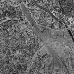


Nearby single photograph taken: June 26, 1963 (0.9 km from this spot)
What to compare in this era: The group of rectangular buildings larger than their surroundings on the west side of the station. If you move to today's photograph, the same area has been replaced by tall buildings with large white roofs
Controls: drag to move / right-drag to rotate and tilt / scroll while holding ⌘ or Ctrl to zoomControls: slide with two fingers to move / pinch to zoom / drag two fingers up or down to tilt
Note: the 3D elevation data is based on current surveys, not on the terrain at the time of the photograph. Elevation tiles: processed from GSI Tiles
The 3D view could not be loaded. Check your connection and try again.
Note: the terrain shading is based on current surveys, not on the terrain at the time of the photograph. Hillshade map: processed from GSI Tiles
Note: the map is today's, not a map from the time of the photograph. Map: © OpenStreetMap contributors
Source: processed from GSI Tiles (aerial photographs by era / latest nationwide photographs / single photographs)
Explore this area on the mapMove the map to compare the surroundings then and now as well.
Overlay and compare the 1961-1969 aerial photograph and today's photograph of the Osaki Garden City area, Tokyo. All photographs are published by the Geospatial Information Authority of Japan (GSI).
Eras of photographs for this location
For the Osaki Garden City area, aerial photographs from the following eras can be compared.
The old photographs of this location cover 7 eras from c. 1936-1942 to 1987-1990; as of 2026, the newest photograph, 1987-1990, is 37 years ago.There are no photographs of this location from after that until today. The differences between eras are summarized in the guide to aerial photograph eras.
Coverage for each era differs by region. Only the eras that actually have photographs of this location are listed here.
Elevation of this location
The elevation (above sea level) near Osaki Station is 4.2 m (source: GSI elevation API). Elevation profiles running east-west and north-south through this location are also shown.
Profile positions (vertical green line = north-south / horizontal blue line = east-west)
Elevation is the value at the ground surface (even where a station is underground or elevated, the value is for the ground surface). Elevation is only one factor in disaster preparedness. Check actual risks such as flooding on the Hazard Map Portal Site and the hazard maps published by local governments.
Elevation tiles for the profiles: processed from GSI Tiles
Access by rail
Osaki Station is served by the following lines.
- Rinkai Line
- JR East Yamanote Line
Source of line information: processed from National Land Numerical Information (Railway Data / Ministry of Land, Infrastructure, Transport and Tourism).
Change seen in the share of built-up area
This compares land use in 1976 and 2021. The share of built-up area within 500 m changed from 99% to 95%. Among the locations on this site, the spread of built-up area here is among the smallest (bottom 20%). The bar below shows where this location falls in the distribution across the locations on this site.
Source: processed from National Land Numerical Information (Land Use Subdivision Mesh / 1976 and 2021 / Ministry of Land, Infrastructure, Transport and Tourism). The texture value (amount of fine detail) of the photographs changed from 15.5 to 41. This is a mechanical comparison between photographs and includes differences from the shooting season and from black and white versus color, so treat it only as a rough guide.
Official land prices over time
The official land price (Chika Koji) standard site nearest to this location is "4-213-16 Osaki, Shinagawa Ward, Tokyo" (about 495 m in a straight line; use: Residential). The official prices per square meter at this standard site from 1987 to 2026 are shown below. The 2026 official price is 1,000,000 yen.
View as a table
| Year | Official price |
|---|---|
| 1987 | 1,000,000 yen |
| 1988 | 1,200,000 yen |
| 1989 | 1,130,000 yen |
| 1990 | 1,130,000 yen |
| 1991 | 1,130,000 yen |
| 1992 | 1,040,000 yen |
| 1993 | 840,000 yen |
| 1994 | 690,000 yen |
| 1995 | 655,000 yen |
| 1996 | 605,000 yen |
| 1997 | 585,000 yen |
| 1998 | 560,000 yen |
| 1999 | 540,000 yen |
| 2000 | 523,000 yen |
| 2001 | 495,000 yen |
| 2002 | 488,000 yen |
| 2003 | 483,000 yen |
| 2004 | 480,000 yen |
| 2005 | 480,000 yen |
| 2006 | 501,000 yen |
| 2007 | 578,000 yen |
| 2008 | 630,000 yen |
| 2009 | 560,000 yen |
| 2010 | 518,000 yen |
| 2011 | 513,000 yen |
| 2012 | 509,000 yen |
| 2013 | 509,000 yen |
| 2014 | 520,000 yen |
| 2015 | 550,000 yen |
| 2016 | 578,000 yen |
| 2017 | 600,000 yen |
| 2018 | 641,000 yen |
| 2019 | 682,000 yen |
| 2020 | 726,000 yen |
| 2021 | 718,000 yen |
| 2022 | 728,000 yen |
| 2023 | 758,000 yen |
| 2024 | 809,000 yen |
| 2025 | 894,000 yen |
| 2026 | 1,000,000 yen |
Source: processed from National Land Numerical Information (Land Price Publication Data / Ministry of Land, Infrastructure, Transport and Tourism). Official land prices are values published for standard sites as of January 1 each year and do not show the transaction price of any particular piece of land. The selection and location of standard sites may be reviewed from year to year.
Nearby locations
Sorted by distance from Osaki Garden City. Comparing them together shows how the same area has changed over time.
Select a marker on the map to see the location name and a link to it.
Locations with the same origins
Towns in the same category as Osaki Garden City (Former factory site), chosen from other regions. You can compare what they share in land use and town layout.
Select a marker on the map to see the location name and a link to it.
Articles that feature this location
Recently viewed towns
This history is saved only on your device and is not sent to any server. Depending on your browser settings, it may be deleted automatically if you do not visit for a while (it is less likely to be deleted if you use the site as an app).
Why not look at how another town has changed?
History of Osaki Garden City
Osaki in Shinagawa Ward, Tokyo, lies at the bottom of a narrow valley cut by the Meguro River. The ground on the three sides facing the valley is low: 4.2 m at the center, 3.4 m in the east and 3.8 m in the north. In contrast, it reaches 15.8 m at the western edge and 12.5 m at the southern edge. It is land with a difference of 12 m between the valley bottom and its edges. Work that needs wide, flat surfaces comes into the low places, and houses line up on the high places. The past aerial photographs open in seven eras, and whichever one you choose, this division appears in the frame. Between the oldest photograph and the newest of the past ones, about fifty years pass.
Why the valley bottom was chosen
The Meguro River comes down cutting between the plateaus, enters from the upper left of the frame, skims the north of the station and passes out to the southeast. The flat land along the stream is narrow, and slopes rise immediately from both sides. The band where roads for carrying goods and water could be secured together was limited to the small width of this valley bottom. When Osaki Station opened in 1901, a third condition, the railway, was added there. The low land, where the means of shipping goods out had come together, was taken by factories before homes. Since the lowness of a valley is also a property tied to how easily water collects, please also look at the hazard map that the ward publishes officially for the assumptions about rain and river water.
The valley bottom in seven eras
The oldest photograph, from around 1936-42, is black and white with coarse grain, and the outlines of roofs are blurred. Even so, in the upper right corner of the frame you can see parallel lines spreading in a bundle. A track running vertically lies in the center, and from the upper left to the center a wide road descends diagonally. A site where long, narrow buildings are lined up facing the same direction lies in the lower middle. The lower left is a cluster of small roofs, and beyond it the city area continues to the edge of the frame.
The 1945-50 photograph has strong contrast, with white and black clearly divided. In the upper right of the frame a dark rectangular water surface and a shore cut in straight lines appear. The river course passing above the center shines white, and even the shape of its meanders can be followed. The row of long buildings in the lower middle is easier to read building by building than in the previous era. In the left half there is almost no space between roofs, and no open land can be found.
If you switch to 1961-69, the frame fills with fine roofs. On the west side of the station, several rectangular buildings of a different size from the surrounding rows of houses are grouped together, with the outline of the site divided by straight lines. The roofs of the buildings shine whitish and look like one block of surface within a photograph filled with fine patterns. Almost no narrow roads pass inside the site, which is divided differently from the streets outside. South of the station the tracks split in a Y shape, and large buildings are placed between them too. In the lower middle, parallel buildings and bundles of tracks extend long and vertically. The contrast of large surfaces lined up on the valley bottom and small roofs packed on the slopes above is clearest in this photograph.
In 1974-78 color is added, but the colors are faded, with strong green and ocher. The bundle of lines at the upper right becomes ocher, and in the lower middle bright surfaces of bare ground and rows of large buildings line up. Only one lot at the lower left has a brighter tone, and a seam is visible. 1979-83 is sandy all over, taken in a season when the green of trees is scarce. A blue rectangular water surface appears at the upper left, and blue roofs begin to mix in among the buildings in the lower middle. 1984-86 is dark and bluish overall, and a large light-blue roof and a surface with a fine grid sit on the same site.
In the 1987-90 photograph, large light-blue and gray roofs line up on the site west of the station. In the lower middle a large blue roof and ocher bare ground lie next to each other, and to their east many tracks extend in parallel. Orange roofs have been added to the bundle of lines at the upper right. A small water surface surrounded by trees lies above the center, different in tone from the way the surrounding roofs are packed. Only the valley bottom moves, and the rows of houses on the slopes above hardly change shape whichever era you choose.
From factories to blocks
On a valley bottom where factories gathered, the position changes when the direction of the means of transport changes. In 2002, a line from the waterfront area was extended to Osaki Station, and the station became a knot for transfers. Once it became a place from which both central Tokyo and the bay area could be reached in a short time, the reason for factories to keep holding land of the same size weakened. The site that had been used as an electrical machinery factory moved its production role elsewhere, and in the late 2010s it opened as blocks combining offices, homes and a plaza people can walk through. As an example of one wide lot changing its role entirely, there is also the waterfront of Toyosu in Tokyo.
Today's valley bottom and the record of values
In today's photograph, tall buildings with large white roofs gather around the station, and elevated roads pass between them. In the lower middle the bundle of parallel tracks remains, and the shape of the long, narrow yard is almost the same as in the past eras. The left half remains a cluster of houses, but the green of trees has increased in patches. It can be read that only the valley bottom was replaced and the slopes above were left as they were.
The record of official land prices (Chika Koji) is at a residential area in Osaki 4-chome, 495 m away. It begins at 1,000,000 yen per square meter in 1987, jumps to 1,200,000 yen in the following year, 1988, and hits the ceiling up to the 2026 publication. From there it enters a long decline, and the 480,000 yen of 2004 and 2005 is the lowest value up to the 2026 publication. In the 2026 publication it is 1,000,000 yen, having recovered to a little over 80% of 1988. The high prices set while the factories were running and the values after the former site changed into blocks lie on the same single line graph.
Work that needed a wide surface came into the bottom of the valley, and after that work left, another wide surface came in. The change is in the contents; the container is still the valley. If you go back and forth between the seven eras, you can see that the area that changed fits neatly in the band of the valley bottom.